...
In addition, CORDEX data for CDS includes Persistent IDentifiers (PID) in their metadata which allows CDS users to report any error during the scientific analysis. The error will be at least documented on the ESGF Errata Service (http://errata.es-doc.org), but also planned to be documented in the CDS. The CDS aims to publish only the latest versions of the datasets.
Domains
We are aiming at publishing various CORDEX domains for the entire World. The CDS-CORDEX subset at the moment consists of the Europe (EURO), Mediterranean (MED), North America (NAM), Arctic (ARC), Africa (AFR) and South America (SAM) CORDEX domainspublish simulations for all CORDEX domains worldwide and consequently all 14 domains are available in the CDS. The dataset was aligned with the CORDEX/RCM data underpinning the AR6 report of IPCC. See detailed information about the RCMs used for CORDEX at https://www.ipcc.ch/report/ar6/wg1/downloads/report/IPCC_AR6_WGI_AnnexII.pdf (Tables AII.1, AII.2, AII.3 and AII.4). More details of the entire list of CORDEX domains can be found at https://cordex.org/domains/; additionally more details for the EURO-CORDEX and NA-CORDEX activities are available at https://www.euro-cordex.net/ and https://na-cordex.org/, respectively..
| Note |
|---|
Please note that the domains are not on regular grids (refer to domain details links for information on the grids used). Projections may differ depending on the domain and the Regional Climate Model (RCM). The coordinates below are the approximate maximum and minimum values of the domain window (see more details at https://cordex.org/domains/. |
...
*The MENA domain is sometimes referred to with the acronym MNA in the names of files retrieved from the CDS, as served from ESGF.
Experiments
The CDS-CORDEX subset consists of the following CORDEX experiments partly derived from the CMIP5 ones:
...
| Note |
|---|
Orography and land area fraction variables are time independent model fields. |
| Name | Short name | Units | Description |
|---|---|---|---|
| 2m temperature | tas | K | The temperature of the air near the surface (or ambient temperature). The data represents the mean over the aggregation period at 2m above the surface. |
| 200hPa temperature | ta200 | K | The temperature of the air at 200hPa. The data represents the mean over the aggregation period at 200hPa pressure level. |
| Minimum 2m temperature in the last 24 hours | tasmin | K | The minimum temperature of the air near the surface. The data represents the daily minimum at 2m above the surface. |
| Maximum 2m temperature in the last 24 hours | tasmax | K | The maximum temperature of the air near the surface. The data represents the daily maximum at 2m above the surface. |
| Mean precipitation flux | pr | kg.m-2.s-1 | The deposition of water to the Earth's surface in the form of rain, snow, ice or hail. The precipitation flux is the mass of water per unit area and time. The data represents the mean over the aggregation period. |
| Mean evaporation flux | evspsbl | kg.m-2.s-1 | The mass of surface and sub-surface liquid water per unit area ant time, which evaporates from land. The data includes conversion to vapour phase from both the liquid and solid phase, i.e., includes sublimation, and represents the mean over the aggregation period. |
| 2m surface relative humidity | hurs | % | The relative humidity is the percentage ratio of the water vapour mass to the water vapour mass at the saturation point given the temperature at that location. The data represents the mean over the aggregation period at 2m above the surface. |
| 2m surface specific humidity | huss | Dimensionless | The amount of moisture in the air at 2m above the surface divided by the amount of air plus moisture at that location. The data represents the mean over the aggregation period at 2m above the surface. |
| Surface pressure | ps | Pa | The air pressure at the lower boundary of the atmosphere. The data represents the mean over the aggregation period. |
| Mean sea level pressure | psl | Pa | The air pressure at sea level. In regions where the Earth's surface is above sea level the surface pressure is used to compute the air pressure that would exist at sea level directly below given a constant air temperature from the surface to the sea level point. The data represents the mean over the aggregation period. |
| 10m Wind Speed | sfcWind | m.s-1 | The magnitude of the two-dimensional horizontal air velocity. The data represents the mean over the aggregation period at 10m above the surface. |
| Surface solar radiation downwards | rsds | W.m-2 | The downward shortwave radiative flux of energy per unit area. The data represents the mean over the aggregation period at the surface. |
| Surface thermal radiation downward | rlds | W.m-2 | The downward longwave radiative flux of energy inciding on the surface from the above per unit area. The data represents the mean over the aggregation period. |
| Surface upwelling shortwave radiation | rsus | W.m-2 | The upward shortwave radiative flux of energy from the surface per unit area. The data represents the mean over the aggregation period at the surface. |
| Total cloud cover | clt | Dimensionless | Total refers to the whole atmosphere column, as seen from the surface or the top of the atmosphere. Cloud cover refers to fraction of horizontal area occupied by clouds. The data represents the mean over the aggregation period. |
| 500hPa geopotential | zg500 | m | The gravitational potential energy per unit mass normalized by the standard gravity at 500hPa at the same latitude. The data represents the mean over the aggregation period at 500hPa pressure level. |
| 10m u-component of wind | uas | m.s-1 | The magnitude of the eastward component of the wind. The data represents the mean over the aggregation period at 10m above the surface. |
| 10m v-component of wind | vas | m.s-1 | The magnitude of the northward component of the wind. The data represents the mean over the aggregation period at 10m above the surface. |
| 200hPa u-component of the wind | ua200 | m.s-1 | The magnitude of the eastward component of the wind. The data represents the mean over the aggregation period at 200hPa above the surface. |
| 200hPa v-component of the wind | va200 | m.s-1 | The magnitude of the northward component of the wind. The data represents the mean over the aggregation period at 200hPa pressure level. |
| 850hPa U-component of the wind | ua850 | m.s-1 | The magnitude of the eastward component of the wind. The data represents the mean over the aggregation period at 850hPa pressure level. |
| 850hPa V-component of the wind | va850 | m.s-1 | The magnitude of the northward component of the wind. The data represents the mean over the aggregation period at 850hPa pressure level. |
| Total run-off flux | mrro | kg.m-2.s-1 | The mass of surface and sub-surface liquid water per unit area and time, which drains from land. The data represents the mean over the aggregation period. |
| Mean evaporation flux | evspsbl | kg.m-2.s-1 | The mass of surface and sub-surface liquid water per unit area ant time, which evaporates from land. The data includes conversion to vapour phase from both the liquid and solid phase, i.e., includes sublimation, and represents the mean over the aggregation period. |
| Land area fraction | sftlf | % | The fraction (in percentage) of grid cell occupied by land surface. The data is time-independent. |
| Orography | orog | m | The height above the geoid (being 0.0 over the ocean). The data is time-independent. |
Data Format
The CDS subset of CORDEX data are provided as NetCDF files. NetCDF (Network Common Data Form) is a file format that is freely available and commonly used in the climate modelling community. See the more details: What are NetCDF files and how can I read them
...
- The Quality Assurance compliance checking tool from DKRZ is used to check that:
- the file name adheres to the CORDEX file naming convention,
- the global attributes of the NetCDF file are consistent with filename,
- there are no omissions of required CORDEX metadata.
- The CF-Checker Climate and Forecast (CF) conventions checker (included in the QA-DKRZ) ensures that any metadata that is provided is consistent with the CF conventions.
The figure below shows a scheme that classifies the tests performed by the QA-DKRZ tool in twelve categories (in green) showing the specific tests/checks in each case.
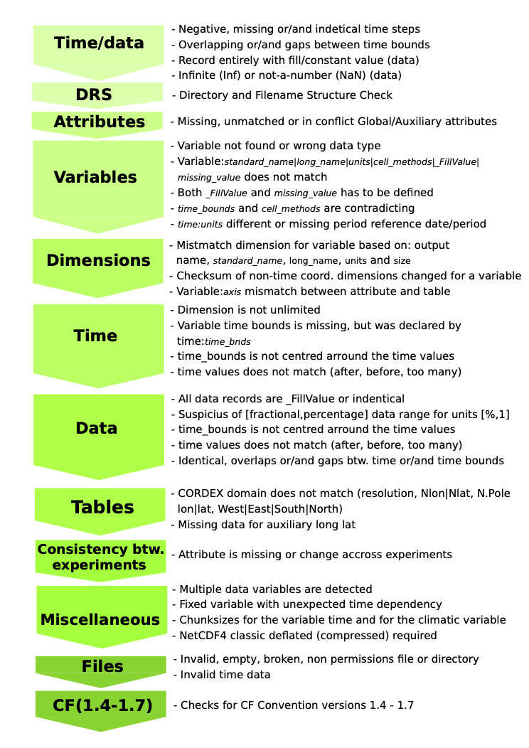
- When possible (i.e., optional), the Time Axis checker developed by the IPSL is used to check the temporal dimension of the data:
- for individual files the time dimension of the data is checked to ensure it is valid and is consistent with the temporal information in the filename,
- where more than one file is required to generate a time-series of data, the files have been checked to ensure there are no temporal gaps or overlaps between the files.
...
All known issues about CORDEX data are documented through the ES-DOC Errata Service : https://errata.es-doc.org/. The Errata Service also includes a command-line interface and an API to request the issue database for a specific dataset or file.
Please note that we have updated the catalogue entry on 14/12/2022 and we have removed some old, obsolete datasets and replaced them by their latest versions. This concerns the following models and simulations:
- EUR-11 domain:
- GERICS/ICHEC-EC-EARTH/rcp45/REMO2015
- DMI/ICHEC-EC-EARTH/historical/DMI-HIRHAM5
- DMI/ICHEC-EC-EARTH/rcp26/r3i1p1/DMI-HIRHAM5
- DMI/ICHEC-EC-EARTH/rcp45/DMI-HIRHAM5
- DMI/ICHEC-EC-EARTH/rcp85/DMI-HIRHAM5
DMI/MOHC-HadGEM2-ES/historical/DMI-HIRHAM5
- DMI/MOHC-HadGEM2-ES/rcp85/DMI-HIRHAM5
DMI/NCC-NorESM1-M/historical/DMI-HIRHAM5
DMI/NCC-NorESM1-M/rcp45/DMI-HIRHAM5
DMI/NCC-NorESM1-M/rcp85/DMI-HIRHAM5
- AFR-44 domain:
- AFR-44/DMI/ECMWF-ERAINT/evaluation/DMI-HIRHAM5
- MED-44 domain:
- ICTP/ECMWF-ERAINT/evaluation/ICTP-RegCM4-3
- ICTP/MOHC-HadGEM2-ES/historical/ICTP-RegCM4-3
In addition:
- Please have a look on the Errata Service to be warned about deprecated CORDEX runs that will be retracted in the future.
- Please note that not all combinations of models and domains exists. This feature is due to the different CORDEX initiatives/consortiums that do not involved involve the same data producers using the same RCMs.
- Please note that not all the combinations of models and variables exist. This feature is inherited from the ESGF system, where the main target is to publish as much as possible data and even publish incomplete datasets, which might be of use. This allows to have more data available with the price that not everything is fully complete.
Some additional minor points which are useful to note:
- For some GCM-RCM combinations, due to the nature of the model configuration, the data surrounding the RCM domain is still included by the files served from ESGF (which would mean that even a global domain might be provided). This will be apparent from the latitude and longitude coverage of the file obtained, and the high resolution domain needs to be extracted (for example LMDZ4NEMOMED8).
Background documents and user guides
...
CORDEX-CORE (comprehensive and homogeneous projections across almost all CORDEX domains with 0.22º resolution):
- Teichmann, C., Jacob, D., Remedio, A.R. et al. (2020) Assessing mean climate change signals in the global CORDEX-CORE ensemble. Clim Dyn. https://doi.org/10.1007/s00382-020-05494-x
- Coppola, E., Raffaele, F., Giorgi, F. et al. (2021) Climate hazard indices projections based on CORDEX-CORE, CMIP5 and CMIP6 ensemble. Clim Dyn. https://doi.org/10.1007/s00382-021-05640-z
| Info | ||
|---|---|---|
| ||
This document has been produced in the context of the Copernicus Climate Change Service (C3S). The activities leading to these results have been contracted by the European Centre for Medium-Range Weather Forecasts, operator of C3S on behalf of the European Union (Delegation Agreement signed on 11/11/2014 and Contribution Agreement signed on 22/07/2021). All information in this document is provided "as is" and no guarantee or warranty is given that the information is fit for any particular purpose. The users thereof use the information at their sole risk and liability. For the avoidance of all doubt , the European Commission and the European Centre for Medium - Range Weather Forecasts have no liability in respect of this document, which is merely representing the author's view. |
...