...
| Info | ||
|---|---|---|
| ||
On 8 March 2016, ECMWF upgraded the horizontal resolution of its analyses and forecasts.The upgrade has a horizontal resolution that translates to about 9 km for HRES and the data assimilation (the outer loop of the 4D-Var) and to about 18 km for the ENS up to day 15. The resolution of the ENS extended (day 16 up to day 46) is about 36 km. A new cycle of the IFS has been introduced to implement the horizontal resolution upgrade. This cycle is labelled 41r2 and includes a number of enhancements to the model and data assimilation listed herein. The detailed specification of the resolution upgrades included in IFS cycle 41r2 are:
These upgrades
During the Release Candidate test phase forecast data will be made available close to real time via |
The page will be updated as required. It was last changed on 8 April 2016.
For a record of changes made to this page please refer to Document versions.
Further information and advice regarding the upgrade can be obtained from User Support.
...
| Table of Contents | ||||
|---|---|---|---|---|
|
...
The planned timetable for the implementation of IFS cycle 41r2 is as follows:
| Date | Event |
|---|---|
| 4 Nov 2015 | Initial announcement to Member States and other forecast users |
| 8 Dec 2015 | Availability of test data in dissemination |
| 14 Jan 2016 | Test data in dissemination available at upgraded resolution |
| 9 Feb 2016 | Update of default software versions at ECMWF |
| 8 Mar 2016 | Expected date of implementation |
The timetable represents current expectations and may change in light of actual progress made.
...
Comparison of scores between IFS cycle 42r1 41r2 and IFS cycle 41r1 for HRES and ENS can be found in the IFS cycle 41r2 scorecard.
...
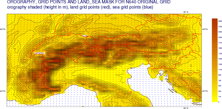
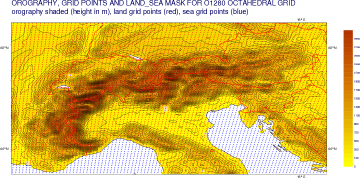
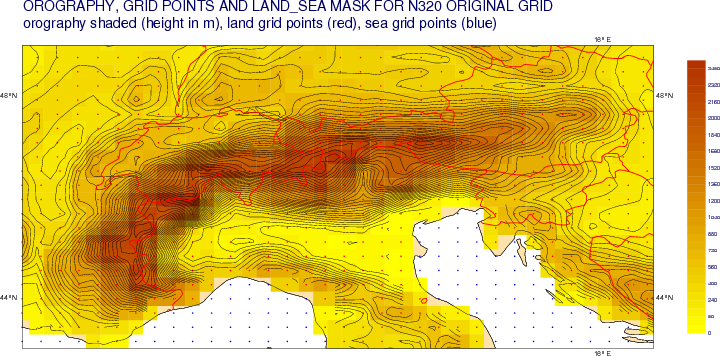
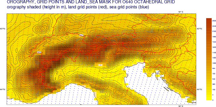
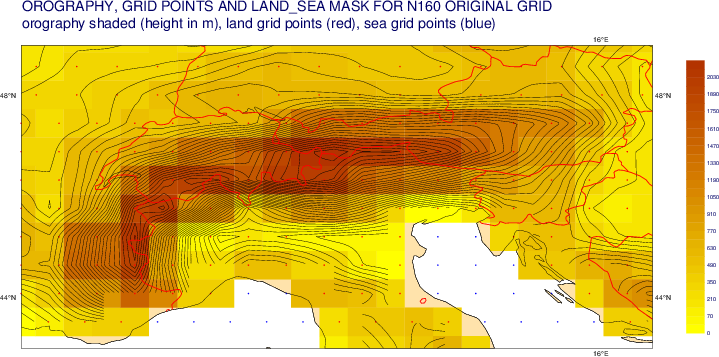
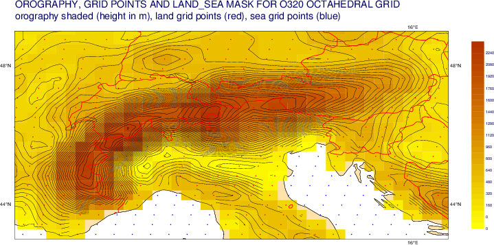
The figures below show the grid spacing and orography fields in a cylindrical projection for HRES, ENS and ENS Extended comparing old (41r1, left) and new (41r2, right) resolutions over a region covering the Alps (43.0°S to 49.0°N, 4.5°E to 17.0°E).
HRES
| Old: N640 original reduced Gaussian grid (~16 km resolution) | New: O1280 octahedral reduced Gaussian grid (~9 km resolution) |
|---|---|
...
ENS
| Old Day 0 - 10: N320 original reduced Gaussian grid (~32 km resolution) | New Day 0 - 15: O640 octahedral reduced Gaussian grid (~18 km resolution) |
|---|---|
| Old Day 11 - 46 : N160 original reduced Gaussian grid (~64 km resolution) | New Day 16 - 46: O320 octahedral reduced Gaussian grid (~36 km resolution) |
| Note |
|---|
The octahedral reduced Gaussian grid has a slightly lower resolution than the corresponding original reduced Gaussian grid with the same number of latitude lines. For example, the O640 grid has a resolution of ~18 km whereas the resolution of the N640 grid is ~16 km. |
...
The increase in horizontal resolution for HRES and ENS is reflected in changes to the GRIB headers. For the model reduced Gaussian grid these are documented in the table below.
| GRIB 1 Section 2 Octets | GRIB 2 Section 3 Octets | grib_api key | HRES | ENS | ENS Extended | |||
|---|---|---|---|---|---|---|---|---|
| Old | New | Old (Day 0 - 10) | New (Day 0 - 15) | Old (Day 11 - 46) | New (Day 16 - 46) | |||
|---|---|---|---|---|---|---|---|---|
| 9-10 | 35-38 | Nj | 1280 | 2560 | 640 | 1280 | 320 | 640 |
| 11-13 | 47-50 | latitudeOfFirstGridPointInDegrees | 89.892 | 89.946 | 89.784 | 89.892 | 89.570 | 89.784 |
| 18-20 | 56-59 | latitudeOfLastGridPointInDegrees | -89.892 | -89.946 | -89.784 | -89.892 | -89.570 | -89.784 |
| 21-23 | 60-63 | longitudeOfLastGridPointInDegrees | 359.859 | 359.929 | 359.718 | 359.860 | 359.437 | 359.722 |
| 26-27 | 6-7 | N | 640 | 1280 | 320 | 640 | 160 | 320 |
| 33-nn | 35-nn | pl | N640 | O1280 | N320 | O640 | N160 | O320 |
Model identifiers
The GRIB model identifiers (generating process identification number) for the new cycle will be changed as follows:
| GRIB 1 Section 1 Octets | GRIB 2 Section 4 Octets | grib_api key | Component | Model ID | |
|---|---|---|---|---|---|
| Old | New | ||||
| 6 | 14 | generatingProcessIdentifier | Atmospheric model | 145 | 146 |
| Ocean wave model | 111 | 111 | |||
| HRES stand-alone ocean wave model | 211 | 211 | |||
| Note | |||||||||||||||||||||
|---|---|---|---|---|---|---|---|---|---|---|---|---|---|---|---|---|---|---|---|---|---|
Note that the identifiers for the wave models have not changed. The identifiers have also not been updated for a a number of HRES analysis products arising from the surface analysis:
The identifiers for these 6 surface analysis parameters will be updated to 146 during the week beginning 14 March 2016. |
...
An additional diagnostic for freezing rain accumulation during the forecast is introduced. CAPE-Shear, previously introduced for the EFI, will be provided also for the HRES and ENS. A new wave product will also be introduced. The availability of test data for these new parameters is indicated in the table below will be updated as the products become available.
| paramId | shortName | name | units | GRIB edition | Component | Test data |
|---|
| available | Dissemination | Proposed for Catalogue | ||||
|---|---|---|---|---|---|---|
| 228216 | fzra | Accumulated freezing rain | m | 1 | HRES / ENS |
| TBC | ||||||||
| 228044 | capes | Convective available potential energy shear | m2/s2 | 1 | HRES / ENS | TBC | TBC | |
| 140120 | sh10 | Significant wave height of all waves with period larger than 10s | m | 1 | HRES-WAM / ENS-WAM / HRES-SAW | TBC | TBC |
Correction to solar zenith angle for the sunshine duration diagnostic
...
Not all grid names and grid number combinations are supported. MARS requests specifying an unsupported grid will fail. Currently, the Gaussian grid names and numbers supported for MARS retrievals are:
| Octahedral reduced Gaussian (O grids) | O1280 | O640 | O512 | O400 | O320 | O256 | O200 | O160 | O128 | O96 | O64 | O48 | O32 |
| Original reduced Gaussian (N grids) | N640 | N512 | N400 | N320 | N256 | N200 | N160 | N128 | N96 | N64 | N48 | N32 | |
| Regular (Full) Gaussian (F grids) | F1280 | F640 | F512 | F400 | F320 | F256 | F200 | F160 | F128 | F96 | F64 | F48 | F32 |
For example, a retrieval request with GRID=N1280 or GRID=O124 will return an error. See Gaussian Grids supported by MARS and Dissemination for a list of the Gaussian grid names and numbers supported for MARS retrievals.
In addition, the MARS post-processing keywords GAUSSIAN=REDUCED and GAUSSIAN=REGULAR are deprecated.
- If the GAUSSIAN keyword is used along with, e.g. GRID=O640, GRID=N640 or GRID=F640 then it is ignored.
- A MARS request with GRID=640, GAUSSIAN=REDUCED returns the original reduced Gaussian grid with 640 latitude lines between pole and equator (equivalent to GRID=N640).
- Similarly, a MARS request with GRID=640, GAUSSIAN=REGULAR returns the full (regular) Gaussian grid with 640 latitude lines between pole and equator (equivalent to GRID=F640).
- A MARS request with GRID=640 only (no GAUSSIAN keyword) returns the full (regular) Gaussian grid with 640 latitude lines between pole and equator (equivalent to GRID=F640).
MARS requests specifying GRID=AV will return the model grid. After the implementation of IFS cycle 41r2, this will be O1280 for HRES, O640 for ENS (Day 0 - 15) and O320 for ENS Extended (Day 16 - 46).
The MARS keyword RESOL=N128 was used to truncate products from ENS Day 0 - 10 to the N=128 original reduced Gaussian grid of ENS Day 11 - 15 prior to interpolation to regular latitude-longitude grids. Following the horizontal resolution upgrade, anyone using this intermediate interpolation method should use RESOL=O320 to truncate O640 ENS Days 0 -15 products to the O320 octahedral grid of ENS Extended (Days 16 - 46).
...
| Note |
|---|
A bug has been fixed which will change results for interpolations from global grid point fields to regular lat-lon or regular Gaussian grids. The problem and the specific cases where differences can occur are described in Bug fix implemented in EMOSLIB 4.3.x. We are happy that these changes are correct but further evaluation by ECMWF is ongoing. If further issues are found then these will be addressed and an updated version of EMOSLIB released. Therefore we ask users to test and evaluate EMOSLIB 4.3.7 carefully before using it operationally. |
...
Magics versions from 2.26.0 provide support for visualisation of products on the octahedral reduced Gaussian grid. Users are recommended to upgrade to Magics 2.26.2 which is the default version in use on ECMWF systems since 9 February 2016 and can be downloaded from the Magics Releases page.
| Anchor | ||||
|---|---|---|---|---|
|
The MARS language changes described above apply also to the web based dissemination requirements tool. In particular, the specification of Gaussian grid products has changed in the MARS language
...
New octahedral grid based products can be requested by specifying GRID=O1280, etc.The following grid numbers are supported for all Gaussian grid names - full (F-grids), original reduced (N-grids) and octahedral reduced (O-grids) :
| HRES | 1280 | 640 | 400 |
|---|
| 256 | 200 | 160 | 128 | 80 | 48 | 32 | ||
| ENS (Days 0 - 15) |
|---|
| 640 |
| 320 |
| 200 | 160 | 128 | 80 | 48 | 32 | |
| ENS-Extended (Days 16 - 46) |
|---|
| 320 |
| 200 | 160 | 128 | 80 | 48 | 32 |
As before, any sub-area of the global field is supported
...
Member State users of the "Simple time-critical jobs" framework can test that their scripts will work with the IFS cycle 41r2 test data by using the special 'events' set up for this purpose:
| identifier | Name | Description |
|---|---|---|
| 1490 | e_ms090 | At this stage, the e-suite step 090 (HRES-BC) has been generated. |
| 1491 | e_ms144 | At this stage, the e-suite step 144 (ENS-BC) has been generated. |
| 1492 | e_ms240 | At this stage, the e-suite step 240 (HRES) has been generated. |
| 1493 | e_ms360 | At this stage, the e-suite step 360 (ENS) has been generated. |
| 1494 | e_mslaw | At this stage, the e-suite step law (HRES-SAW) has been generated. |
| 1495 | e_ms1104 | At this stage, the e-suite step refc (REFORECAST) has been updated. |
For these events, MSJ_EXPVER environment variable is set to 0069 and can be used to specify the IFS cycle 41r2 test data any MARS retrievals.
...
| Note |
|---|
Users with scripts subscribed to the fc00hmetgram or fc12hmetgram events for the HRES "classic" meteogram should note that the product is discontinued with the introduction of IFS cycle 41r2. See ENS meteograms above for details. Jobs subscribed to this event will not be triggered following the implementation of IFS cycle 41r2. Anyone using this event to trigger scripts that undertake processing other than the plotting of the HRES meteograms are advised to use instead the fc00h240 and fc12h240 events. |
...
Option 2 or 3 time-critical applications can be tested with the IFS cycle 41r2 test data retrieved from MARS or received in Dissemination.
Availability of IFS cycle 41r2 test data
...
- HRES (class=od, stream=oper, expver=69)
- Wave HRES (class=od, stream=wave, expver=69)
- ENS (class=od, stream=enfo, expver=69)
- WAM ENS (class=od, stream=enfo, expver=69)
| Warning |
|---|
The data are intended for testing technical aspects only and should not be used for operational forecasting. Only data from 12 UTC on 9 November 2015 have been produced with the corrected land-sea mask and other climatological fields. An error in the precipitation type diagnostic (ptype, 260015) in the test data was corrected for the 12 UTC run on 8 Dec 2015. Cold phase precipitation types were missing or misrepresented. The precipitation type diagnostic should therefore only be used after this date. All registered users of ECMWF computing systems will be able to access the test data sets in MARS. Users of our operational real time forecasts without access to our systems can contact our Data Services to obtain test data. |
...
Since 8 December 2015, IFS cycle 41r2 test Dissemination data is available through the test dissemination system, close to real time. Up to 14 January 2016, IFS cycle 41r2 dissemination products were based on users' operational dissemination requirements, backwards compatible with the IFS cycle 41r1.
...
- Internet transfers: 193.61.196.104 (ecpds-xma.ecmwf.int) 193.61.196.105 (ecpds-xmb.ecmwf.int)
- RMDCN transfers: 136.156.8.132 (mspds-dm4.ecmwf.int)
Should you require any assistance with IFS cycle 41r2 test dissemination products, please contact Unknown User (maj).
...
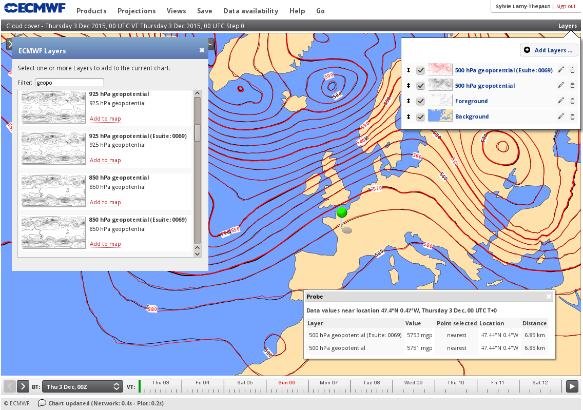
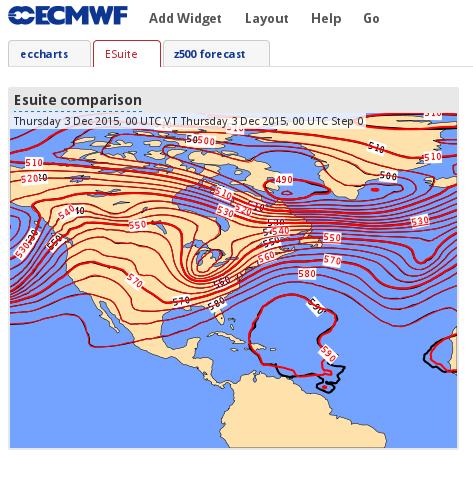
IFS cycle 41r2 test data is accessible via the ecCharts layers menu, identified by the label "esuite 0069" as shown in the screenshot on the left. They can be displayed as any other layers of ecCharts, and they can be saved in the Dashboard, as seen in the screenshot on the right.
| Column |
|---|
| Column |
|---|
The point probe and time series tools will be also available for the 41r2 test data.
...
| Anchor | ||||
|---|---|---|---|---|
|
| Date | Reason for update |
|---|---|
| 4 November 2015 |
|
| 8 December 2015 |
|
| 14 January 2016 |
|
| 10 February 2016 |
|
| 10 March 2016 |
|
| 8 April 2016 |
|
