AIFS Single The Deterministic Model
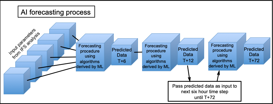
Observations are assimilated using 4D-var to IFS grid point values over the whole globe with resolution about 9km. Currently the AI procedures use grid points at a lower resolution about 0.25 of a degree (~25km). The IFS analysed data is "encoded" to values at the AI grid point. These data are then fed to the AI procedure which uses the algorithms derived by the ML trained by minimising RMS error. The algorithm is not complicated and consequently has fast execution allowing a complete global forecast to be made much faster than IFS and other physics-based models. Forecasts are made in six hour time steps and output from one time step is used as the input for the next step. Currently the AI forecasts use 12 repeated six hour time steps to extend the forecast to T+72. Intermediate forecast data is only available at the simulated six hour time steps; no information is available at smaller intervals than six hours.
The limitation in horizontal and vertical resolutions mean that:
- Interpretation is necessary before using any forecast product.
- it is only possible to derive a few post-processed products (e.g. precipitation and convective precipitation).
Making a forecast with AI is very efficient. It requires only a single Graphics Processing Unit (GPU), takes less than a minute to run, and consumes a tiny fraction of the energy required for an IFS forecast. This brings the prospect of more frequent and/or quite large, ensembles of AI forecasts.

Fig5: Forecasting process using AI for forecasts to T+72. The forecast proceeds in six hour time steps with the output from one step presented as data to the next step. Forecast data is available for six hour intervals out to T+72. The output data at each six hour forecast intervals is "decoded" from the AI grid points back to IFS resolution and may then be used for constructing charts of the parameters.
Observed data analysed using 4D-Var is delivered to the IFS grid points and then "encoded" to the AI grid points. The AI forecasting process uses the algorithms to produce predicted data from the encoded data.
Points to consider when using AIFS output
AIFS forecasts:
- verification scores are better than classical NWP models at all lead times.
- tend to be less jumpy than classical NWP models in successive forecasts.
- large scale propagation is handled better than classical NWP models.
- have low spatial resolution (0.25 deg horizontally, pressure levels vertically). This reduces the ability to deliver certain products to a useable standard (e.g. vertical profiles).
- fine-scale details, as in Ensemble Control Forecast (ex-HRES) are missing (e.g. for precipitation).
- many desirable parameters are currently missing or are unreliable (e.g. MUCAPE, convection, convective precipitation, cloud, visibility, precipitation type, snow, gusts etc.). However, this may well be a short-term limitation.
- At longer lead times:
- Increasingly smooth look to fields - increasingly 'implausible' output (even if RMSE looks very good).
- Fewer, smoother short wavelength features.
- Reduced gradient strengths (e.g. frontal zones systematically broaden then disappear).
- Some extreme weather events appear less intense (e.g. windstorms which appear less intense than IFS but are nevertheless indicated).
- Temperature extremes are more consistently handled, generally beating classical NWP deterministic forecasts.
Practical use of AIFS output
Forecasters should:
- Focus on known strengths (e.g. broadscale pattern, tropical cyclone paths).
- Steer well clear of more 'sophisticated'/detailed outputs (e.g. looking at rain over upslopes).
- Try to link broadscale pattern to 'weather' or indeed other classical NWP output fields (e.g. in clusters/regimes that match). A type of fingerprinting approach might be useful.
- Be very wary of using output in a direct way to predict most types of weather extremes. 2m temperature extremes are the exception - forecasts of these are often as good as IFS.
- Be ready for unforeseen outcomes (e.g. extreme noise, semi-permanent upper low over Middle East, precipitation totals not adding up).
- Expect the unexpected (e.g. odd behaviours, at least from time to time!).
- Don't expect inter-variable correlations to always match up with classical ideas or classical NWP. ERA5 learning should have reduced discrepancies but anomalies do occur (e.g. currently it is quite common to see convective precipitation greater than total precipitation.
- Note that guidance could change from day to day. ML models continue to develop and improve with corresponding changes in results.
- Broadscale forecasts score better than classical NWP. However, shorter wave length features and fine detail is not well captured, particularly as forecast lead time increases.
The dissemination schedule is given in Section 3.1:
(FUG Associated with Cy49r1)
