Contributors: J. Bannwart (University of Zurich), I. Dussaillant (University of Zurich), F. Paul (University of Zurich), M. Zemp (University of Zurich)
Issued by: UZH / Ines Dussaillant
Date: 04/10/2023
Ref: C3S2_312a_Lot4.WP1-PDDP-GL-v2_202306_MC_PQAD-v5_i1.1
Official reference number service contract: 2021/C3S2_312a_Lot4_EODC/SC1
History of modifications
List of datasets covered by this document
Related documents
Acronyms
General definitions
Brokered Product: A brokered product is a pre-existing dataset to which the Copernicus Climate Change Service (C3S) acquires a license, for the purpose of including it in the Climate Data Store (CDS).
Elevation change: Vertical change in glacier surface elevation (altitude), typically derived from two elevation measurements, adjusted if necessary for the difference of their respective datum surfaces, at the same (or nearly the same) horizontal coordinates (Cogley et al., 2011).
Geodetic method: Any method for determining mass balance by repeated mapping of glacier surface elevations to estimate the volume balance; cartographic method and topographic method are synonyms. The conversion of elevation change to mass balance requires information on the density of the mass lost or gained, or an assumption about the time variations in density (Cogley et al., 2011).
Glaciological method: A method of determining mass balance in-situ on the glacier surface by measurements of accumulation and ablation, generally including measurements at stakes and in snow pits; direct method has long been a synonym. The measurements may also rely on depth probing and density sampling of the snow and firn, and coring. They are made at single points, the results from a number of points being extrapolated and integrated to yield the surface mass balance over a larger area such as an elevation band or the entire glacier (Cogley et al., 2011).
Gravimetric (Gravity) method: A technique in which glacier mass variations are calculated from direct measurements of Earth's gravity field. Satellite gravimetry is at present the most feasible method for determining glacier mass balance from changes in gravity. The Gravity Recovery and Climate Experiment (GRACE) consists of two polar-orbiting satellites separated by about 200 km along-track, and is the primary mission for this work to date (Cogley et al., 2011).
Remote sensing: Measurement of surface properties with a sensor distant from the surface, such as on an airplane or satellite, or of subsurface properties with a sensor on or distant from the surface, either with a signal emitted by the sensor (Cogley et al., 2011)
Scope of the document
This document is the Product Quality Assurance Document (PQAD) for the glacier change service providing a global gridded annual glacier mass change product to the Climate Data Store (CDS) of the Copernicus Climate Change Service (C3S). It describes the product and datasets to be validated along with the methods that will be used for validation. Previous glacier products were provided to the CDS as separate glacier elevation and mass change datasets (C3S). Both of these datasets had been extracted from the Fluctuations of Glaciers (FoG) database brokered from World Glacier Monitoring Service (WGMS)1. Within C3S2, we now combine these two datasets to produce a completely new and unique product of global distributed glacier changes. Consequently, major changes have been applied to the glacier change product and quality assurance methods.
The present PQAD document complements the corresponding submission of the glacier mass change Climate Data Record (CDR) towards the end of the second data cycle within C3S2 312a (glacier change product version WGMS-FOG-2023-09, December 2023). The distributed glacier mass-change product builds on the latest Fluctuations of Glaciers Database version released in 09 2023 by the World Glacier Monitoring Service (WGMS, 2023)2.
Executive summary
This document provides a description of the gridded glacier-change product Climate Data Record (CDR) version WGMS-FOG-2023-09) provided by the C3S Glacier Change Service to the Climate Data Store (CDS) along with the methods that will be used for validation and quality assessment The Glacier Change Service addresses the essential climate variable (ECV) Glacier and provides a globally gridded product of annual glacier mass-changes with a spatial resolution of 0.5° x 0.5° covering the hydrological years from 1975/76 to 2021/22.
Due to the global incompleteness of glacier change observations in the past, the glacier datasets provided to the CDS consisted of independent glacier elevation and mass change time series compiled from the available research data coming from in-situ, air and space borne methods. They represented direct extracts from the Fluctuations of Glaciers (FoG) database, brokered from WGMS (wgms.ch). During recent years, the geodetic method has become a popular tool to measure glacier elevation changes over large glacierized regions with high accuracy for multiannual/decadal time periods. Consequently, the sample of geodetic observations available from the FoG database has been increasing fast and is expected to further grow in the future. It changed from a largely incomplete (9% of the world glaciers in Zemp et al. (2019)) to a nearly complete coverage in only few years (96% of the worldwide glacier area, Hugonnet et al. (2021)). Thanks to this increased global completeness, it is now for the first time possible to combine the glaciological and the geodetic sample to develop a globally distributed glacier change product, bridging the gap on spatio-temporal coverage of glacier change observations.
In this document we provide the context of this new global glacier change product and describe the potential solutions for product validation. In section 1 we describe the product to be validated. The global gridded annual glacier change dataset provided for the CDS by the glacier change service is a combination of three datasets: (1) the glacier distribution from the globally complete Randolph Glacier Inventory (RGI) and the (2) mass balance and (3) elevation change observations from the Fluctuations of Glaciers (FoG) database. The recently developed approach to combine these three datasets allows to provide annual glacier mass change and related uncertainties for every glacier since 1976 updatable on a yearly basis. To produce the annually resolved global gridded glacier mass change product CDR, the glacier-specific time series are integrated into a 0.5° regular grid resolution.
The CDS glacier change product is a one-of-a-kind dataset. Since it builds on all available glacier change observations available from the glaciological community through the Fluctuations of Glaciers (FoG) database, there are no independent validated reference datasets to compare it with for accuracy assessment. Therefore, validation and accuracy assessment of the C3S glacier change product is limited to four general levels:
(i) Peer review system of original data publication in an academic journal
(ii) The evaluation of the uncertainty information submitted with the input data
(iii) Leave one out cross validation on reference glaciers
(iv) Comparison with previous global glacier change assessments
Points (i) and (ii) relate to the glaciological and geodetic time series used as input data and are briefly discussed in Section 2. Further information can be found in WGMS, (2022) and in Zemp et al. (2013, 2015, 2019) ). The uncertainty assessment of the global gridded annual glacier mass-change product CDR is extensively described in [RD1].
Section 3 describes the strategies to achieve points (iii) and (iv). First, we provide a brief summary of the leave-one-out cross validation methodology and propose a comparison with observation based or independent global glacier change assessments. At the time of writing this document (June 2023), the new version of gridded glacier-change product (version WGMS-FOG-2023-09) is still in progress, validation results will not be discussed in this document but in the associated Product Quality Assessment Report [RD4].
1. Validated products
The gridded glacier-change product (version WGMS-FOG-2023-09 and earlier version) provided for the CDS by the glacier change service is a combination of three datasets: the glacier distribution from the globally complete Randolph Glacier Inventory (RGI) and the mass and elevation change observations from the Fluctuations of Glaciers (FoG) database (see sections 2.1and 2.2, respectively) that is brokered from the World Glacier Monitoring Service (WGMS, 2023 and earlier versions). The elements of these datasets are described in more detail in the Algorithm Theoretical Basis Document (RD1) and the Product User Guide and Specification document (RD3). The dataset consists of a global assessment of annual glacier mass change and related uncertainties for every individual glacier in the RGI6.0 from 1976 to present. It is provided in a 0.5° (lat-lon) global regular grid as the total mass of water (Gigatons, Gt) lost/gained by the glacier surface within a grid cell in yearly netCDF4 files.
It is important to note that the input datasets used to produce the gridded glacier change product are validated independently. The mass balance time series are regularly calibrated with the geodetic method to adjust for possible systematic trends of the field measurements (Zemp et al., 2013). The geodetic measurements (elevation changes) have no direct validation, but include an uncertainty assessment of their input datasets (two digital elevation models (DEMs) from two points in time) over stable terrain. Usually, both DEMs are co-registered between each other (using one as reference) and residual biases and random noise over stable terrain are reported as a measure of accuracy (Rolstad et al., 2009; Hugonnet et al., 2021). The evaluation of the uncertainty information submitted with the input data will support the uncertainty assessment of our distributed product (Section 3.1).
Only a few of the entries in the CDR dataset are validated as part of the C3S service in the classical sense. This is because we can only validate our methodology using the input dataset entries that have already been independently validated: the WGMS reference glaciers (see Section 3.1.1). For a comprehensive validation of the gridded glacier change product we will rely mostly on the leave-one-out experiment over reference glaciers (Section 3.1).
2. Description of validating datasets
2.1. Glacier mass changes
Glacier mass changes are obtained in the field by measuring accumulation and ablation of snow and ice over one year or seasonally (at the end of winter and summer) at a couple of stakes and pits on the glacier (the latter include density measurements for volume to mass conversion). These point datasets are then extrapolated to the entire glacier using a range of methods (e.g. mean value per elevation bin or with the contour method). A detailed review of such measurements and possibilities for spatial interpolation are provided in Zemp et al. (2013). The resulting dataset is a validation dataset for remote sensing based assessments or for calibration and validation of numerical models simulating mass balance (e.g. Giesen and Oerlemans, 2013). However, systematic errors in the in-situ measurements can introduce a bias that increases with time and needs to be corrected by independent assessment. In general, this is achieved using elevation changes derived from the geodetic method using DEMs from at least two points in time (e.g. Huss et al., 2009; Zemp et al., 2013; Thomson et al., 2017). The time period between the two DEMs used for the calculation of elevation changes should be long enough to prevent short-term glacier dynamics (emergence in the ablation and submergence in the accumulation regions) from biasing the measurements. About 475 glaciers in the world have field measurements and they are well distributed through all the RGI first Order glacier regions (Figure 1). Only 40 of these glaciers have been monitored in a continuous way during a sufficiently long period of time (more than 30 years) and have been corrected by independent assessment using geodetic estimates. These correspond to the WGMS reference glaciers (see Section 3.1.1).
2.2. Glacier elevation changes
Glacier elevation changes can be obtained from remote sensing data using a range of methods, including the pure trend detection at individual points (e.g. Ice, Cloud and Elevation Satellite (ICESat) footprints). The review paper by Bhardwaj et al. (2016) provides an overview of related studies. Field observations of cumulative mass balance can be used for validation of remotely sensed datasets. However, normally the opposite is true, i.e., elevation changes (geodetic mass balance) are used for calibration of the field measurements. Where possible, the source DEMs used for the geodetic assessment have been validated against an independent dataset (e.g. ICESat or high-resolution national elevation data) over stable terrain. After co-registration of both DEMs and correction of possible dataset related biases due to specific sensor characteristics, satellite trajectories, or variable spatial resolution (Paul, 2008; Nuth and Kääb, 2011; Gardelle et al., 2012), the elevation difference should be zero over stable terrain. Any deviation can be interpreted as an error of the measurement. Therefore, the validation dataset for glacier elevation changes is provided by the DEMs used to determine it. Special care has to be taken when the source DEM is already merged from different datasets and individual parts or even grid cells have a different, maybe even undocumented, time stamp (e.g. the Global Digital Elevation Model (GDEM) or some national DEMs). Only very recently, the geodetic sample has been boosted from a largely incomplete coverage (9% of the world glaciers in Zemp et al. (2019)) to an almost complete sample (96% of glaciers in Hugonnet et al. (2021)) allowing for the first time to have a complete and fully homogeneous coverage of glacier change observation over the last 20 years (Figure 1). 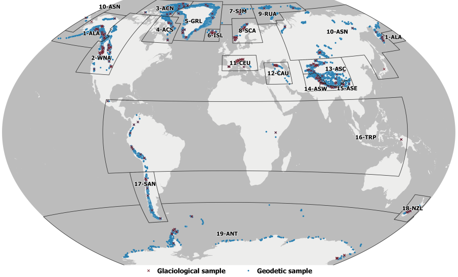
Figure 1: Distribution of glacier fluctuation records from the glaciological (red crosses) and geodetic (blue dots) samples over the 19 RGI 1st order regions (black boxes, label: Region number-glacier region code). Glacier fluctuation data from WGMS (2022), glacier regions from RGI6.0 and country boundaries from Natural Earth.
2.3. Global Gridded annual glacier mass change product
The Global gridded annual glacier mass change product delivered to the CDS uses the latest version of the glacier mass and elevation changes from the FoG database (WGMS, 2023-09) together with the glacier extents from the RGI6.0 as input. A new methodological approach combining these three datasets based on previous work from Zemp et al. (2019, 2020) was developed in order to enable resolving glacier changes at an improved spatial resolution (individual glacier scale) and temporal resolution (annual). In order to meet the requirements of CDS data users, these individual glacier changes will be integrated and delivered in a global regular grid at a given spatial resolution. Results are provided at a 0.5° resolution (pixel size) on a geographic latitude/longitude global regular grid (Figure 2).

Figure 2: Globally distributed annual glacier mass changes. Visualization example of the observationally calibrated glacier changes (in Gt) for the hydrological year 2016/17, spatially distributed in a global regular grid of 0.5° (latitude/longitude).
3. Description of product validation methodology
3.1. Leave one out cross validation
This section briefly describes the validation methodology for the global gridded annual glacier mass-change product version WGMS-FOG-2023-09. Since it builds on all available glacier change observations available, there are no independent validated reference datasets to compare it with for accuracy assessment. Therefore, we propose to validate our results with an independent leave-one-out crossed validation experiment (see Section 3.1.2) over selected reference glaciers, i.e. glaciers having already validated observations.
3.1.1. WGMS Reference Glaciers
With the reference glaciers, the World Glacier Monitoring Service (WGMS) aims at providing a reliable and well-documented sample of globally distributed long-term observation series to document the impact of climate change on glacier mass-balance (Figure 3). The reference glaciers have more than 30 years of ongoing glaciological mass-balance measurements. Thanks to the wealth of data and long-term observation series, the WGMS reference glaciers represent excellent test sites for the validation of glaciological and geodetic data and related production methods. They are used here as the main reference dataset for validation of the C3S global gridded glacier mass-change product CDR.

Figure 3: Global map showing the location of WGMS reference glaciers. Further details can be found on the WGMS reference glacier website3. Data sources: Reference glaciers data from WGMS. Mountains above 1000m (brown shades) from GTOPO30, US Geological Survey (UGS).
3.1.2. Leave one out cross validation methodology
We use 32 reference glaciers for this assessment. For each reference glacier we compare the reference validated mass balance time series, available directly from the FoG database, with the leave-one-out calibrated mass balance series calculated using our methodology (described in detail in RD1).
For the latter, following our original method, we calculate the reference glacier calibrated mass balance series by calibrating the spatial anomaly over the glacier geodetic sample. For the sake of the experiment, the spatial anomaly in this case is obtained as the mean of nearby individual glacier annual anomalies selected by the special search excluding (leaving out) the selected reference glacier from the glaciological sample. The Root Mean Square Error (RMSE) is calculated as a measure of the deviation of the calculated observations from the reference sample, and the r correlation factor as a measure of the correlation between the reference and calculated leave-one-out cross validation time series. The RMSE resulting from this comparison will provide further insight on the validity of our individual glacier accuracy and uncertainty assessment.
The validation results of the last version of the gridded glacier-change product CDR (version WGMS-FOG-2022-09) is available in the associated Product Quality Assessment Report [RD2].
3.1.3. Comparison with previous global glacier change assessments
At the time of writing this document (June 2023), the new version of the gridded glacier-change product CDR (version WGMS-FOG-2023-09) is still in progress. The comparison to previous global glacier mass change assessments of the last version of the gridded glacier-change product CDR (version WGMS-FOG-2022-09) is available in the associated Product Quality Assessment Report [RD2].
We intend to further validate our distributed glacier change product as part of the European Space Agency (ESA) Glacier Mass Balance Intercomparison Exercise4. This project is part of a glaciological community effort to compare the different available methodologies existing to measure regional and global glacier changes (from direct observations, Zemp et al., (2019, 2020) and from GRACE and Cryosat 2, Wouters et al., (2019), Ciracì et al., (2020) and Jakob et al., (2021)). The main objective is to assess the best estimate of glacier changes for every particular glacier region. This intercomparison is beyond the scope of our C3S2 activities, but will help to further improve and validate our glacier CDS distributed glacier change product.
4. Main limitations and future challenges
Thanks to the global completeness of elevation change observations in the FoG database after integration of Hugonnet et al., (2021), it is now possible to produce a distributed glacier change product fitting the user requirements of the CDS with better constrained uncertainties (with respect to the Zemp et al., (2019, 2020) baselines). However, future research is still required to address the uncertainty assessment of the input datasets for glacier elevation and mass changes from FoG in a more accurate way. In simple terms, the better constrained the elevation and mass change input data, the smaller is the error inherited by our final distributed glacier change product. Recent progress in elevation change observations include improvements on the uncertainty assessment of the geodetic method from spaceborne imagery (e.g. Hugonnet et al., 2021) and best practices to interpolate data voids of variable size and location (McNabb et al., 2019). Issues regarding the spatially variable penetration into snow, firn and ice when using radar based DEMs (TanDEM-X DEM, SRTM) is still unsolved and needs further research to result in acceptable products. Mass balance observations can still be improved considering the current approaches for the extrapolation from the observational sample to the total glacier coverage (e.g. Paul and Haeberli, 2008; Cogley, 2009) and promoting the reanalysis of time series with high resolution geodetic data at a regular basis (Zemp et al. 2013 and references therein). Furthermore, in an era being quickly dominated by satellite data, ensuring the continuity of in situ measurements is becoming a pressing issue in order to secure the availability of glacier observations at higher temporal resolution (yearly/seasonal) essential to produce or distributed glacier product.
New issues requiring further consideration in the future arise from the development of the new gridded glacier change product. Improvements are still needed to i) define best practices for propagation of uncertainties from the individual glacier to the grid point, (ii) account for grid point artefacts in polar regions and (iii) account for the differences in observation dates from the elevation and mass change input datasets. These issues are explained below and will be considered in future versions of the distributed glacier change product.
Error propagation: Reported uncertainties for the distributed glacier product are combined as they stem from multiple sources: input data uncertainties, density conversion, area and area changes, data gaps, spatio-temporal extrapolation and aggregation. Combining these errors at the individual glacier scale is relatively simple, but due to error correlations between the datasets, their combination over larger regions is not as simple anymore. For now, our approach stays simple and conservative, based on Zemp et al., 2019, 2020. We expect to improve error propagation in future versions of the glacier CDS product.
Grid-point artefact in polar regions: For mass change purposes a glacier must be considered as a whole, all-in-one system which cannot be divided in parts. The best glaciologically correct solution to integrate glacier changes into a grid point is to consider a glacier belonging to a grid-point when its geometric centroid lies within the grid point. In polar region above 60° latitude, grid points are smaller in surface and individual glaciers can be larger than the 0.5° grid. This directly leads to a biased centroid grid point mass change, and consequent neighboring glacierized grid points without mass change estimate. Although not perfect, we believe this is currently the best solution possible for the glacier CDS product.
Calendar year vs Hydrological year: The distributed glacier product is delivered on a yearly basis assuming the hydrological year to be from January to December over all regions and both Hemispheres. In fact, the hydrological year varies between regions (Southern and Northern Hemispheres and Tropics) and is not equal to the calendar year. This issue may be addressed in future version of our distributed product where we aim at including the seasonality of glacier changes which will allow consideration of the differences between the different regions of the world.
5. Summary of validation results
At the time of writing this document (June 2023), the new version of the gridded glacier-change product CDR (version WGMS-FOG-2023-09) is still in progress. The methodologies described in previous sections will be applied to the new version of the gridded glacier change product in the near future and the validation results will be discussed in a future version of this document and in the associated Product Quality Assessment Report [RD4].
References
Bhardwaj, A., Sam, L., Bhardwaj, A., and Martín-Torres, F. J. (2016). LiDAR remote sensing of the cryosphere: Present applications and future prospects. Remote Sensing of Environment 177, 125–143. doi: 10.1016/j.rse.2016.02.031.
Ciracì, E., Velicogna, I., and Swenson, S. (2020). Continuity of the Mass Loss of the World's Glaciers and Ice Caps From the GRACE and GRACE Follow-On Missions. Geophysical Research Letters 47, e2019GL086926. doi: 10.1029/2019GL086926.
Cogley, J. G. (2009). Geodetic and direct mass-balance measurements: comparison and joint analysis. Annals of Glaciology 50, 96–100. doi: 10.3189/172756409787769744.
Gardelle, J., Berthier, E., and Arnaud, Y. (2012). Impact of resolution and radar penetration on glacier elevation changes computed from DEM differencing. Journal of Glaciology 58, 419–422. doi: 10.3189/2012JoG11J175.
Giesen, R. H., and Oerlemans, J. (2013). Climate-model induced differences in the 21st century global and regional glacier contributions to sea-level rise. Clim Dyn 41, 3283–3300. doi: 10.1007/s00382-013-1743-7.
Hugonnet, R., McNabb, R., Berthier, E., Menounos, B., Nuth, C., Girod, L., et al. (2021). Accelerated global glacier mass loss in the early twenty-first century. Nature 592, 726–731. doi: 10.1038/s41586-021-03436-z.
Huss, M., Bauder, A., and Funk, M. (2009). Homogenization of long-term mass-balance time series. Annals of Glaciology 50, 198–206. doi: 10.3189/172756409787769627.
Jakob, L., Gourmelen, N., Ewart, M., and Plummer, S. (2021). Spatially and temporally resolved ice loss in High Mountain Asia and the Gulf of Alaska observed by CryoSat-2 swath altimetry between 2010 and 2019. The Cryosphere 15, 1845–1862. doi: 10.5194/tc-15-1845-2021.
McNabb, R., Nuth, C., Kääb, A., and Girod, L. (2019). Sensitivity of glacier volume change estimation to DEM void interpolation. The Cryosphere 13, 895–910. doi: https://doi.org/10.5194/tc-13-895-2019![]() .
.
Nuth, C., and Kääb, A. (2011). Co-registration and bias corrections of satellite elevation data sets for quantifying glacier thickness change. The Cryosphere 5, 271–290. doi: 10.5194/tc-5-271-2011.
Paul, F. (2008). Calculation of glacier elevation changes with SRTM: is there an elevation-dependent bias? Journal of Glaciology 54, 945–946. doi: 10.3189/002214308787779960.
Paul, F., and Haeberli, W. (2008). Spatial variability of glacier elevation changes in the Swiss Alps obtained from two digital elevation models. Geophysical Research Letters 35. doi: 10.1029/2008GL034718.
Rolstad, C., Haug, T., and Denby, B. (2009). Spatially integrated geodetic glacier mass balance and its uncertainty based on geostatistical analysis: application to the western Svartisen ice cap, Norway. Journal of Glaciology 55, 666–680. doi: 10.3189/002214309789470950.
Thomson, L. I., Zemp, M., Copland, L., Cogley, J. G., and Ecclestone, M. A. (2017). Comparison of geodetic and glaciological mass budgets for White Glacier, Axel Heiberg Island, Canada. Journal of Glaciology 63, 55–66. doi: 10.1017/jog.2016.112.
WGMS (2022). Fluctuations of Glaciers Database. doi: 10.5904/wgms-fog-2022-09.
Wouters, B., Gardner, A. S., and Moholdt, G. (2019). Global Glacier Mass Loss During the GRACE Satellite Mission (2002-2016). Front. Earth Sci. 7. doi: 10.3389/feart.2019.00096.
Zemp, M., Frey, H., Gärtner-Roer, I., Nussbaumer, S. U., Hoelzle, M., Paul, F., et al. (2015). Historically unprecedented global glacier decline in the early 21st century. Journal of Glaciology 61, 745–762. doi: 10.3189/2015JoG15J017.
Zemp, M., Huss, M., Eckert, N., Thibert, E., Paul, F., Nussbaumer, S. U., et al. (2020). Brief communication: Ad hoc estimation of glacier contributions to sea-level rise from the latest glaciological observations. The Cryosphere 14, 1043–1050. doi: 10.3929/ethz-b-000408094.
Zemp, M., Huss, M., Thibert, E., Eckert, N., McNabb, R., Huber, J., et al. (2019). Global glacier mass changes and their contributions to sea-level rise from 1961 to 2016. Nature 568, 382. doi: 10.1038/s41586-019-1071-0.
Zemp, M., Thibert, E., Huss, M., Stumm, D., Rolstad Denby, C., Nuth, C., et al. (2013). Reanalysing glacier mass balance measurement series. The Cryosphere 7, 1227–1245. doi: 10.5194/tc-7-1227-2013.
This document has been produced in the context of the Copernicus Climate Change Service (C3S).
The activities leading to these results have been contracted by the European Centre for Medium-Range Weather Forecasts, operator of C3S on behalf of the European Union (Contribution agreement signed on 22/07/2021). All information in this document is provided "as is" and no guarantee or warranty is given that the information is fit for any particular purpose.
The users thereof use the information at their sole risk and liability. For the avoidance of all doubt , the European Commission and the European Centre for Medium - Range Weather Forecasts have no liability in respect of this document, which is merely representing the author's view.
