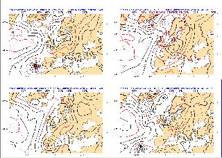
Nadine's future remains as uncertain as it was in the previous forecasts for both its intensity and its track. The extra-tropical tracker again shows two possible movement: eastward and westward.
According to the high-resolution forecast Nadine will move north-eastwards behaving as tropical-like feature. Then it will penetrate inland into the Iberian peninsular dying quickly or merging with a bigger trough.
GFS in its last run from 06UTC predicted a little bit different behaviour of Nadine: again north-eastwards motion, more easterly track, earlier in the forecast and living longer inland causing torrential rain in Portugal and Spain.
Comparing day 6 forecast from the main centres we will see how different they are.
The possibility of Nadine hitting the Iberian peninsular seems to be well captured in EFI forecast of 10-metre wind gusts. The SOT valued are also quite big.
1 Comment
Unknown User (moa) AUTHOR
Yesterday (2.10.2012), Nadine was back in action. Possibly the longest lived tropical cyclone in the Atlantic!
Worth a detailed investigation.