...
MIR can work with shifted grids, with no point at latitude=0, longitude=0. An example would be:
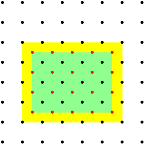
This is done automatically provided the differences between N-S and E-W limits are both divisible by the corresponding increments without remainder. This represents a change in respect to EMOSLIB, which would adjust the area to fit. In the previous example, EMOSLIB would adjust the N/W/S/E boundaries to the more conventional area 90/0/-90/359. In this example the black points represent the original grid with 1 degree spacing. The red points show the user defined area, which has the same spacing but shifted by half a degree. MARS with EMOSLIB would expand the area to fit in the original grid, as seen in the yellow rectangle. MARS with MIR would honour the user defined area and would return the inner grid shown in green. In cases where the differences between N-S and E-W limits are not divisible by the corresponding increments without remainder, MARS with MIR starts from the user-specified south-west corner and goes up to (but does not exceed) the north-east corner. For example, a request specifying:
retrieves |
Land-sea mask processing
By default, MIR does not use land-sea mask processing for any parameters. However, users will be able to specify the land-sea mask to use LSM processing for both input and output grids with the new LSM keyword:
...
