| Table of Contents |
|---|
Preparations
...
Before you start the tutorial you need to execute the following preparatory steps:
...
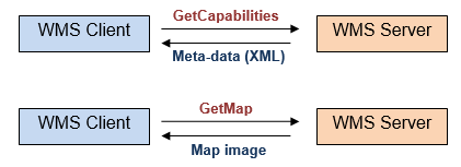
In the WMS transaction the client sends (HTTP) requests to the server which on return sends back the requested information to the client. The WMS standard defines several request types, two of which have to be supported by any WMS servers:
...
...
- GetCapabilities: the server sends back information about the WMS meta-data and the available map layers (typically in XML format).
...
...
- GetMap: based on the specified parameters in the request (e.g. bounding box, geographic coordinate reference system, image size and format etc.), the server returns a map image for a selected layer that can be now visualised by the client.
...
...
The Metview WMS client can perform both of this these request types enabling users to perform the following actions:
...
· Download and examine the WMS capabilities meta-data and build the GetMap request out of it.
...
...
- Perform the GetMap request and visualise the resulting map image as a layer in Metview.
...
...
The WMS standard defines different versions. Metview supports all the versions commonly used to date: 1.0, 1.1, 1.1.1 and 1.3.0.
...
For further information on WMS standards please turn to the official documents available at the OGC web site:
...
http://www.opengeospatial.org/standards
...
Part 2 – Getting started
...
In this exercise we will build a WMS GetMap request for a Sea Surface Temperature layer from the NASA Earth Observations WMS server and visualise the resulting image in Metview.
...
The WMS Client Icon
WMS requests in Metview can be defined and executed by the WMS Client icon. You can find this icon in the icon drawer.
...