| Name
|
Size
|
Creator |
Creation Date
|
Last Modification Date
|
Labels |
Attached To |
|
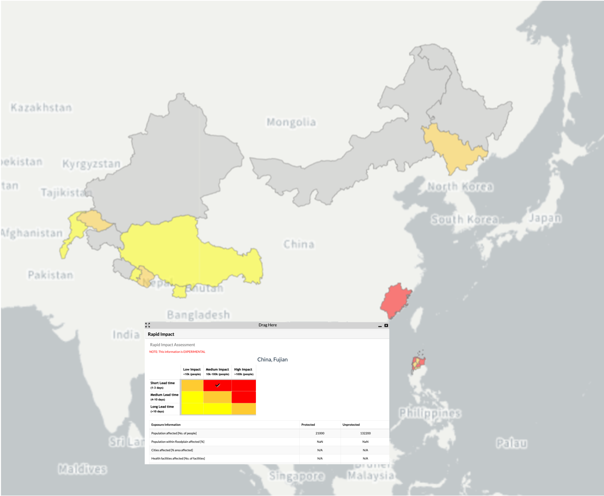
PNG File glofas_ria_example.png |
750 kB |
Calum Baugh |
Jul 26, 2023 18:11 |
Jul 26, 2023 18:11 |
|
Page: CEMS-Flood flood impact forecasting
|
|
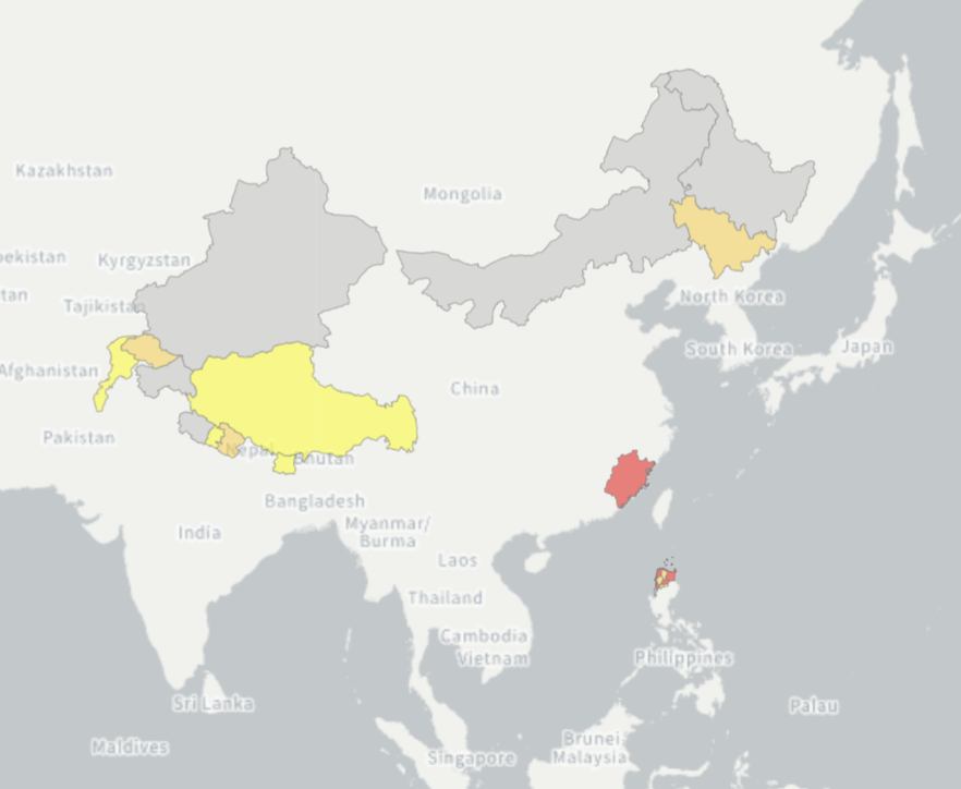
PNG File Screenshot 2023-07-26 at 18.07.21.png |
205 kB |
Calum Baugh |
Jul 26, 2023 18:08 |
Jul 26, 2023 18:08 |
|
Page: CEMS-Flood flood impact forecasting
|
|
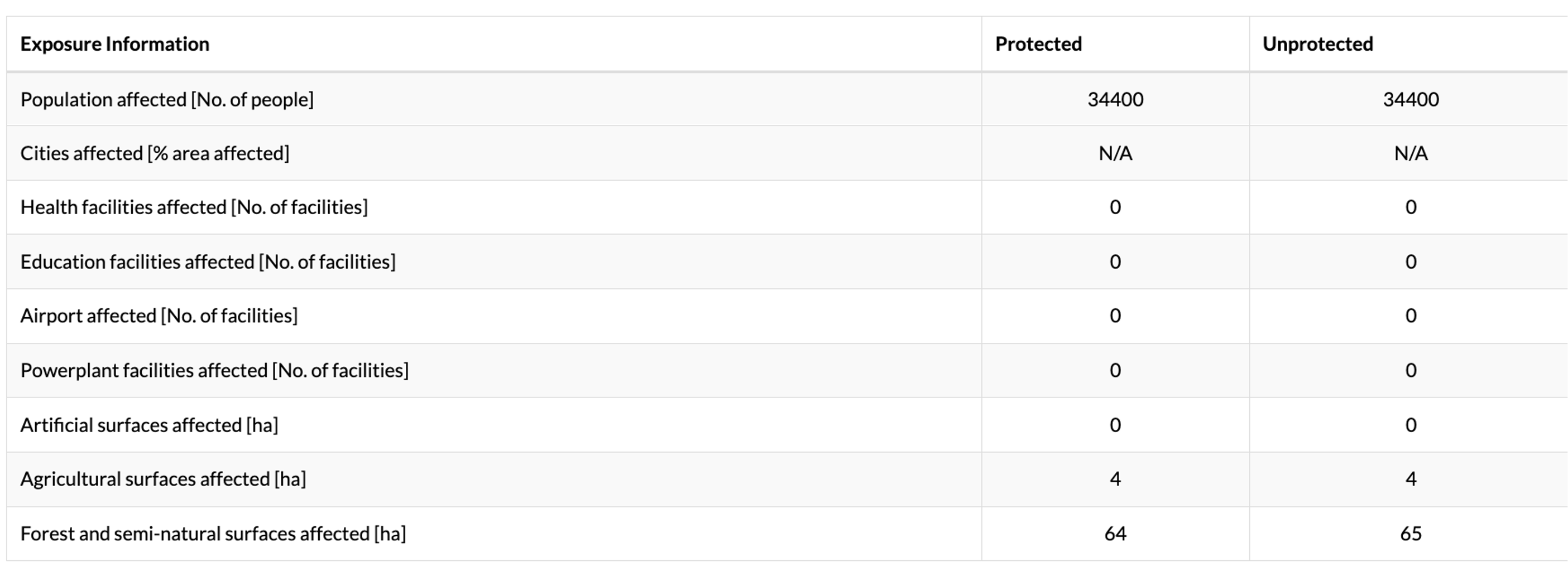
PNG File glofas_rra_exposure_table.png |
270 kB |
Calum Baugh |
Jul 26, 2023 18:03 |
Jul 26, 2023 18:03 |
|
Page: CEMS-Flood flood impact forecasting
|
|
PNG File Screenshot 2023-07-26 at 11.25.38.png |
691 kB |
Calum Baugh |
Jul 26, 2023 16:21 |
Jul 26, 2023 16:21 |
|
Page: CEMS-Flood flood impact forecasting
|
|
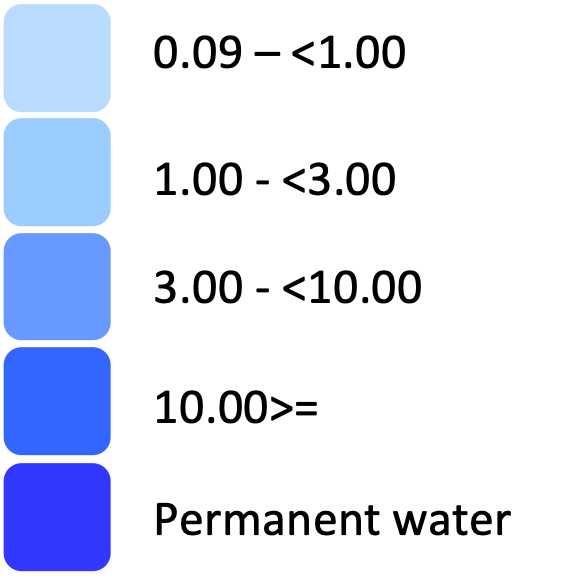
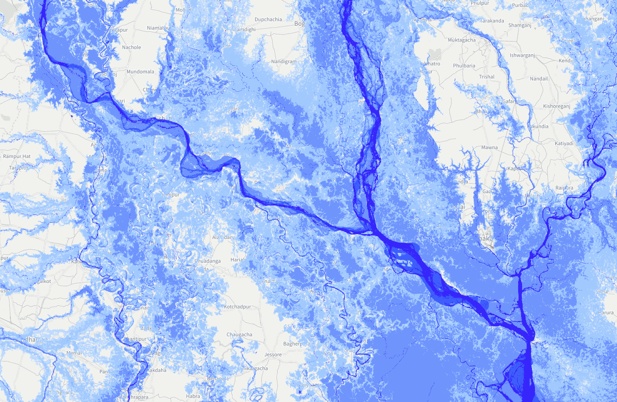
PNG File flood100yr_colorscale.png |
28 kB |
Calum Baugh |
Jul 26, 2023 15:27 |
Jul 26, 2023 15:27 |
|
Page: CEMS-Flood flood inundation maps
|
|
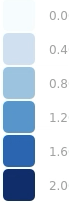
PNG File Screenshot 2023-07-26 at 15.17.56.png |
1.40 MB |
Calum Baugh |
Jul 26, 2023 15:19 |
Jul 26, 2023 15:19 |
|
Page: CEMS-Flood flood inundation maps
|
|
PNG File Screenshot 2023-07-26 at 14.56.54.png |
11 kB |
Calum Baugh |
Jul 26, 2023 14:57 |
Jul 26, 2023 14:57 |
|
Page: CEMS-Flood flood inundation maps
|
|
PNG File Screenshot 2023-07-26 at 12.10.37.png |
791 kB |
Calum Baugh |
Jul 26, 2023 14:55 |
Jul 26, 2023 14:55 |
|
Page: CEMS-Flood flood inundation maps
|
|
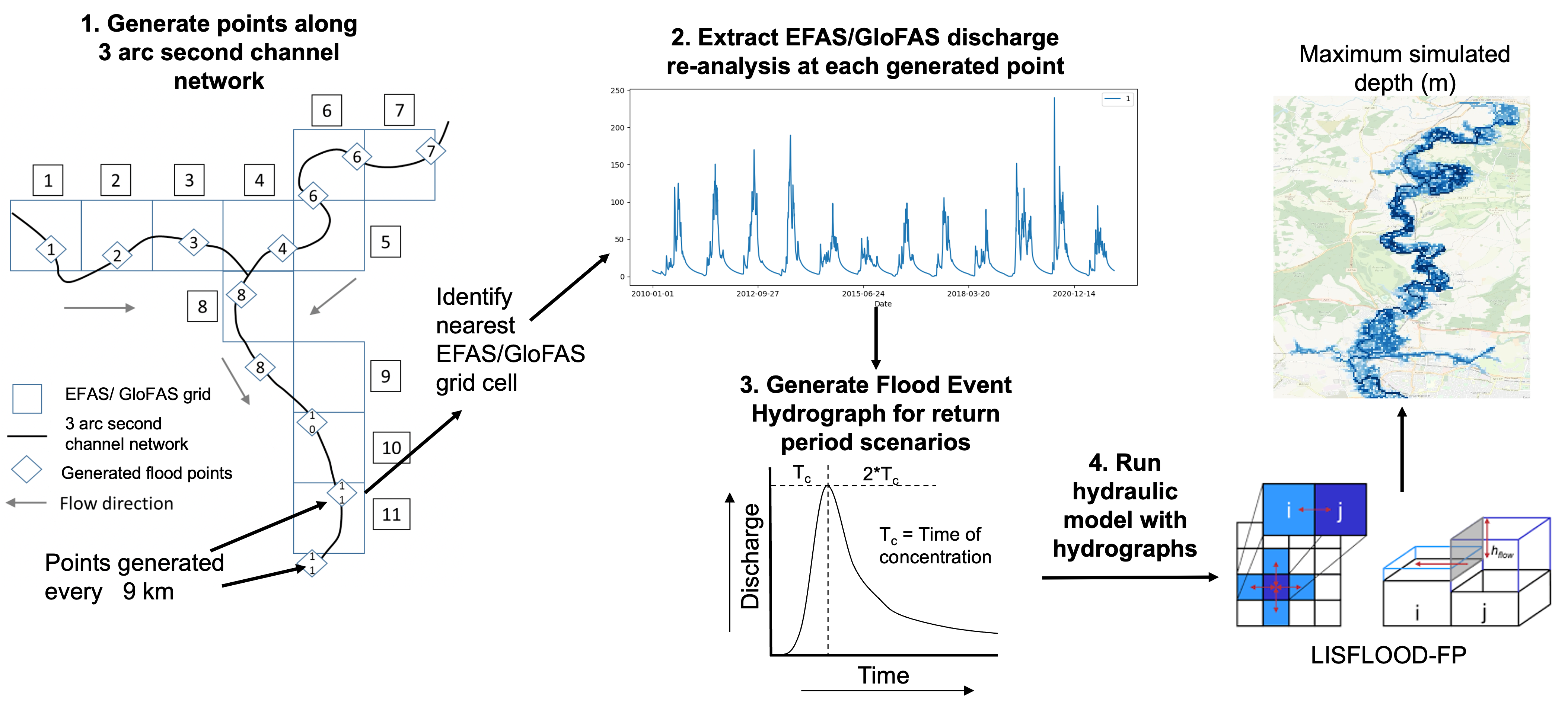
PNG File flood_inundation_method.png |
2.36 MB |
Calum Baugh |
Jul 26, 2023 13:26 |
Jul 26, 2023 13:26 |
|
Page: CEMS-Flood flood inundation maps
|
|
PNG File image-2023-7-19_14-48-0.png |
186 kB |
Francesca Di Giuseppe |
Jul 26, 2023 11:52 |
Jul 26, 2023 11:52 |
|
Page: User Guide for Fire danger indices historical data from the Copernicus Emergency Management Service
|
|
PNG File image-2023-7-26_11-58-43.png |
29 kB |
Francesca Di Giuseppe |
Jul 26, 2023 11:52 |
Jul 26, 2023 11:52 |
|
Page: User Guide for Fire danger indices historical data from the Copernicus Emergency Management Service
|
|
PNG File image-2023-7-26_11-58-25.png |
29 kB |
Francesca Di Giuseppe |
Jul 26, 2023 11:52 |
Jul 26, 2023 11:52 |
|
Page: User Guide for Fire danger indices historical data from the Copernicus Emergency Management Service
|
|
PNG File image-2023-7-26_11-58-5.png |
275 kB |
Francesca Di Giuseppe |
Jul 26, 2023 11:52 |
Jul 26, 2023 11:52 |
|
Page: User Guide for Fire danger indices historical data from the Copernicus Emergency Management Service
|
|
PNG File image-2023-7-26_10-36-41.png |
83 kB |
Francesca Di Giuseppe |
Jul 26, 2023 11:52 |
Jul 26, 2023 11:52 |
|
Page: User Guide for Fire danger indices historical data from the Copernicus Emergency Management Service
|
|
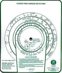
JPEG File mcarthur.jpeg |
13 kB |
Francesca Di Giuseppe |
Jul 26, 2023 11:52 |
Jul 26, 2023 11:52 |
|
Page: User Guide for Fire danger indices historical data from the Copernicus Emergency Management Service
|
|
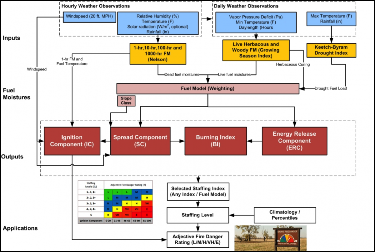
PNG File 437-fire-danger-2016-nfdrs.png |
521 kB |
Francesca Di Giuseppe |
Jul 26, 2023 11:52 |
Jul 26, 2023 11:52 |
|
Page: User Guide for Fire danger indices historical data from the Copernicus Emergency Management Service
|
|
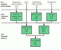
PNG File fwi.png |
6 kB |
Francesca Di Giuseppe |
Jul 26, 2023 11:52 |
Jul 26, 2023 11:52 |
|
Page: User Guide for Fire danger indices historical data from the Copernicus Emergency Management Service
|
|
PNG File Screenshot 2023-07-26 at 11.25.38.png |
691 kB |
Calum Baugh |
Jul 26, 2023 11:26 |
Jul 26, 2023 11:26 |
|
Page: GloFAS Flood Risk Products Overview
|
|
PNG File image-2023-7-26_11-58-43.png |
29 kB |
Francesca Di Giuseppe |
Jul 26, 2023 10:58 |
Jul 26, 2023 10:58 |
|
Page: User Guide
|
|
PNG File image-2023-7-26_11-58-25.png |
29 kB |
Francesca Di Giuseppe |
Jul 26, 2023 10:58 |
Jul 26, 2023 10:58 |
|
Page: User Guide
|