Two weather events have been chosen in order to show the model's capabilities on the one hand, and on the other hand, to provide reference cases for the users (to compare the results of their installed model version with the ones run at ECMWF or to inter-compare the results of different model versions). Important aspects in the selection of the cases were their geographical scope and their physical background, i.e. the focus was on those storm events which had severe impact over Europe and were governed by large-scale dynamical forcings. Cases both with weak and good operational ECMWF IFS forecast skill were considered.

Storm Xaver

A large and violent cyclonic storm hit the North Sea region and several adjacent countries on 5 December 2013. Problems were caused both by the high wind speeds and the related storm surge. The surge reached 6 metres in Hamburg for example and was the highest along the east-coast for 60 years. In the aftermath of the cyclone a blizzard hit Sweden. The storm system was named Xaver by Berlin's Free University; other names assigned elsewhere include Bodil, Sven and St. Nicholas (Hewson et al., 2014). The cyclone developed around 00 UTC on 4 December northeast of Newfoundland and it was situated between converging northerly and southerly airstreams. Due to the westerly wind jet accelerated by the convergence, the cyclone moved northeast and east, deepening explosively. It had an intense meso-vortex back to the west, which enhanced the strong wind (see Figure 1). The cyclone was presented in the operational forecasts 8-9 days before the event and the forecasts indicated the very strong wind gust 3-4 days in advance. Although some strength overestimation over Germany as well as timing error in surface pressure were concluded.

See: Xaver windstorm: ECMWF Severe Event Catalogue


Figure 1: 24-hour maximum wind gust (m/s) on 5 December based on the ECMWF operational IFS forecasts at 00 UTC on 3 and 5 December (left and middle, respectively; with white contours for the mean sea level pressure in hPa on 12 UTC on 5 December) and from the observations (right).

Storm Desmond

Storm Desmond caused severe flooding, travel disruption and a power outage across northern England, parts of Scotland and Ireland on 5 December 2015. Cumbria in the northwestern part of England was one of the worst affected regions with more than 200 mm of rain in 24 hours recorded in that area. Storm Desmond broke the United Kingdom's 24-hour rainfall record, with 341.4 mm of rain falling in Honister Pass, Cumbria. On Saturday, 5 December, the UK Met Office issued a red warning of heavy rain for Cumbria. The cyclone also led to flooding in southern Norway.

Orographical enhancement of the precipitation played the major role in the event and the operational model of ECMWF forecast well the highest rainfall amounts over the orographical barriers. However, the forecast underestimated the peak values of about 100 mm in 24 hours in Cumbria and overestimated the precipitation amount in lee of the hills (Figure 2).

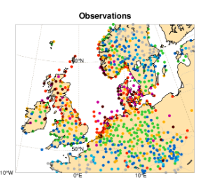
Figure 2: 24-hour precipitation amount (mm) between 6 UTC on 5 December and 6 UTC on 6 December, based on the ECMWF operational IFS forecast at 00 UTC on 5 December (left; with cyan contours for the mean sea level pressure in hPa at 12 UTC on 5 December) and from the observations (right).

References

Hewson, T., Magnusson, L., Breivik, O., Prates, F., Tsonevsky, I., de Vries, H.J.W., 2014: Windstorms in northwest Europe in late 2013. ECMWF Newsletter 139, 22–28. [PDF]


Back to top