MARS/Dissemination
Specifies the target grid which can be either a Gaussian or a Latitude/Longitude grid.
grid=<value> |
|---|
MARS requests specifying grid=av will return the archived model grid. For Latitude/Longitude output, the format is in degrees, i.e. grid = 2.5/2.5, where the first number denotes the east-west resolution (longitude) and the second denotes the north-south resolution (latitude). The grid spacing needs to be an integer fraction of 90 degrees (latitude range from the Equator to the Pole), e.g. 0.225, 0.25, 0.28125, 0.3, 0.4, ...
Output on a Gaussian grid is specified by a letter denoting the type of Gaussian grid followed by an integer (the grid number) representing the number of lines between the Pole and Equator, e.g.
grid = F160- full (or regular) Gaussian grid with 160 latitude lines between the pole and equatorgrid = N320- ECMWF original reduced Gaussian grid with 320 latitude lines between the pole and equator, see Reduced Gaussian Grids for grid numbers used at ECMWFgrid = O640- ECMWF octahedral (reduced) Gaussian grid with 640 latitude lines between the pole and equator
Not all grid names and grid number combinations are supported. Currently, the Gaussian grid names and numbers supported for MARS retrievals are:
| Octahedral reduced Gaussian (O grids) | O1280 | O1024 | O640 | O512 | O400 | O320 | O256 | O200 | O160 | O128 | O96 | O80 | O64 | O48 | O32 |
| Original reduced Gaussian (N grids) | N1280 | N1024 | N640 | N512 | N400 | N320 | N256 | N200 | N160 | N128 | N96 | N80 | N64 | N48 | N32 |
| Regular (Full) Gaussian (F grids) | F1280 | F1024 | F640 | F512 | F400 | F320 | F256 | F200 | F160 | F128 | F96 | F80 | F64 | F48 | F32 |
MARS requests specifying an unsupported grid will fail. For example, a retrieval request with grid=O123 will return an error. If the letter denoting the type of Gaussian grid is omitted, e.g. grid=320, a full (or regular) Gaussian grid with 320 grid lines is returned.
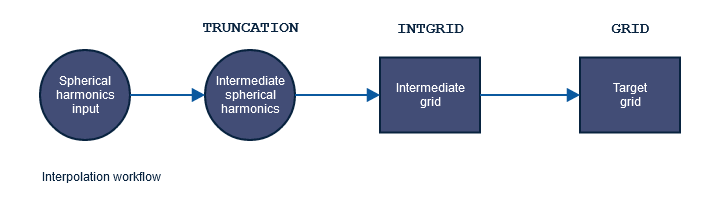
For other keywords controlling the interpolation see the diagram below.
Examples
|
Dissemination lat/lon grids allowed are describe for each data set in the Catalogue pages
4 Comments
Riccardo Monfardini
I have a question, which might be a little basic:
what kind of interpolation is used to go from the original reduced Gaussian Grid to a regular Lat/Lon grid?
Is there a link to the documentation?
Bojan Kasic
Dear Riccardo,
Some information is available on this page: MARS interpolation with MIR#Gridtogridinterpolations
You can find there that interpolation is done with MIR package and for most parameters default liner interpolation is used, but there are few exceptions.
Riccardo Monfardini
I have downloaded with MARS ERA5 and ERA5_Land data. I asked both with grid=0.25/0.25.
How would the land-sea mark be different? should they be different?
Naively I assumed the land-sea mask of ERA5_Land at the same resolution as ERA5 would match, but I am getting an unusual behaviour when looking at the coastlines
Bojan Kasic
Dear Riccardo Monfardini ,
My advice is to open a support ticket describing the issue at: https://confluence.ecmwf.int/site/support
Please attach both download requests and if you have their corresponding outputs. With that, we can start investigating.
Thank you!