Under construction.
This combines information from:
- Validation: EMOS 4.3.2
- EMOS-216 issue: interpolation error analysis (Memo by Pedro Maciel)
- Presentation given at December 2015 FD-RD meeting by Pedro Maciel
The information presented here will be made available to the public under the History of EMOSLIB changes.
Description of the problem
The problem originates in the calculation of the longitude values of the source grid in EMOSLIB routines IRDIWE and IGDIWE. These routines use an integer value of the longitudinal grid increment (the 'stride') which, in some cases, results in a truncated value of the increment. This can result in an error in the computation of the longitude values in the source grid.
- The error occurs whenever the grid spacing Dj=360/Nj at a specific latitude line, j, with Nj longitude points has a remainder smaller than 10 microdegrees (1/100000 of a degree).
- The error accumulates linearly from 0° to 360° along the line of latitude.
- The error is minimal at grid points to the east and maximal at those to the west of the 0° meridian.
- The error is larger the greater the number of longitude points (Nj) along the line of latitude.
When the error occurs, the incorrect computation of the longitude values leads to two issues:
- The longitude points in the source grid are computed incorrectly. This leads to an incorrect computation of interpolation weights and hence to incorrect values at some points of the output grid.
- The nearest grid points used for the interpolation may be incorrectly identified due to a numerical 'shift' of the input grid cell.
The error is most evident for parameters where the gradient of the field is large and where a change in the nearest grid points or the interpolation weights used thus has a larger effect.
Which interpolations are affected ?
The problem affects interpolations from:
- input original reduced Gaussian grid point fields to output regular Gaussian or regular latitude-longitude grids (without rotation)
- input octahedral reduced Gaussian grid point fields to output regular Gaussian or regular latitude-longitude grids (without rotation).
Which interpolations are not affected ?
- Interpolations to rotated latitude-longitude grids are unaffected
- Transformations from spherical harmonic components to grid point fields are unaffected.
- Interpolations of wave (WAM, ENS-WAM etc) fields are unaffected.
For which cases is the problem fixed ?
The issue is fixed in EMOSLIB cycle 000430 and newer for the following cases:
- interpolations from original reduced or octahedral reduced Gaussian grids to global, unrotated regular Gaussian grids (gridType=regular_gg);
- interpolations from original reduced or octahedral reduced Gaussian grids to global, unrotated latitude-longitude grids (gridType=regular_ll).
In which software versions is the problem fixed ?
The issue is fixed in EMOSLIB cycle 000430 and newer. This is used by:
- MARS client to be updated in February 2016 (until then it is available with "mars -t")
- Metview version 4.6.1 and newer
- Disseminated products for IFS cycle 41r2 (implementation planned for March 2016)
For the Disseminated products from IFS cycle 41r2, the problem is also fixed for interpolations to sub-areas of latitude-longitude grids.
For which cases does the problem still exist ?
The issue has not been fixed for the following cases
- interpolations from original reduced or octahedral reduced Gaussian grids to sub-areas of regular Gaussian grids (gridType=regular_gg);
- interpolations from original reduced or octahedral reduced Gaussian grids to sub-areas of unrotated regular latitude-longitude grids (gridType=regular_ll);
- interpolations from original reduced or octahedral reduced Gaussian grids to sub-areas of rotated latitude-longitude grids (gridType=rotated_ll).
Examples
Mean sea-level pressure - global
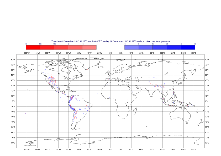
Global differences between old and new methods for interpolation of mean sea-level pressure from the O1280 octahedral reduced Gaussian grid to a 0.5°x0.5° regular latitude-longitude grid for the period 1-14 December 2015.

Global differences between old and new methods for interpolation of mean sea-level pressure from the N640 original reduced Gaussian grid to a 0.5°x0.5° regular latitude-longitude grid for the period 1-14 December 2015.
Mean sea-level pressure - sub-area
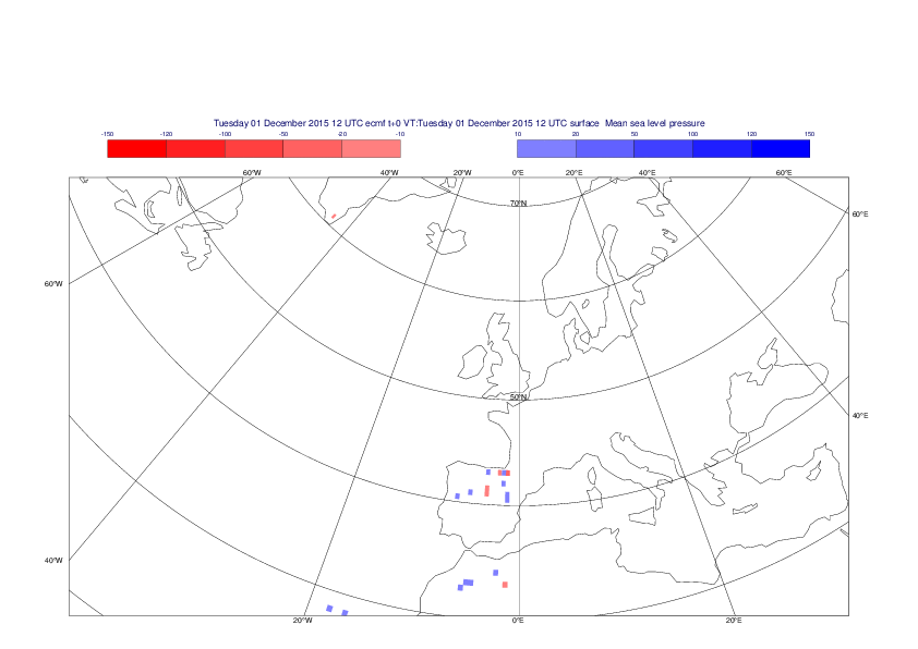
Differences between old and new methods for interpolation of mean sea-level pressure from the O1280 octahedral reduced Gaussian grid to a 0.5°x0.5° regular latitude-longitude grid over Europe for the period 1-14 December 2015.

Differences between old and new methods for interpolation of mean sea-level pressure from the N640 original reduced Gaussian grid to a 0.5°x0.5° regular latitude-longitude grid over Europe for the period 1-14 December 2015.
2 metre temperature - global
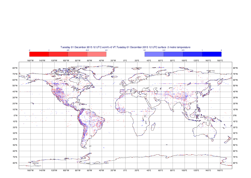
Global differences between old and new methods for interpolation of 2m temperature from the O1280 original reduced Gaussian grid to a 0.5°x0.5° regular latitude-longitude grid for the period 1-14 December 2015.
Differences between old and new methods for interpolation of 2m temperature from the N640 original reduced Gaussian grid to a 0.5°x0.5° regular latitude-longitude grid over Europe for the period 1-14 December 2015.
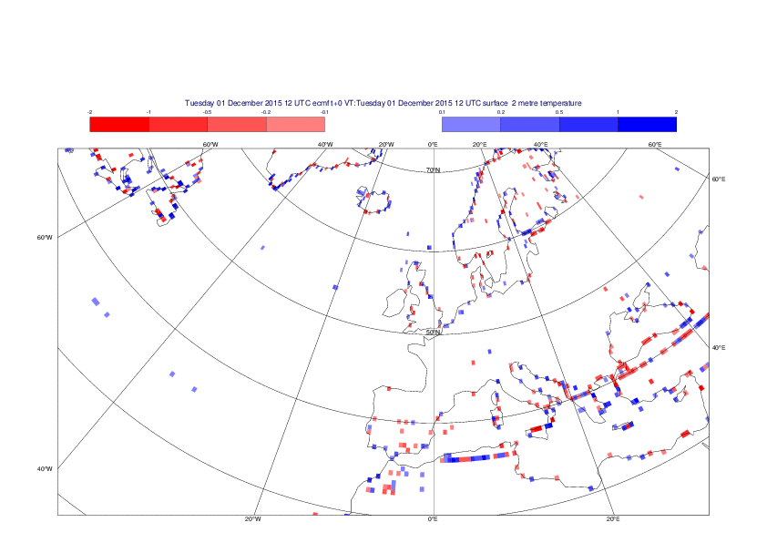
2m temperature - sub-area
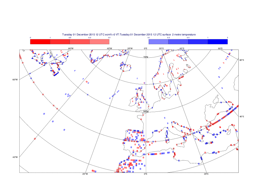
Differences between old and new methods for interpolation of 2m temperature from the O1280 octahedral reduced Gaussian grid to a 0.5°x0.5° regular latitude-longitude grid over Europe for the period 1-14 December 2015.
Differences between old and new methods for interpolation of 2m temperature from the N640 original reduced Gaussian grid to a 0.5°x0.5° regular latitude-longitude grid over Europe for the period 1-14 December 2015.