...
2. Description of the event
The cyclone formed on the 3 November. On the 6 November 00 UTC the cyclone first classified as a super-typhoon. Late on the 7 November the cyclone made landfall on southern Philippines. Just before (18 UTC) the wind speed was (estimated?) 195 mph.
![]()
3. Predictability
3.1 HRES
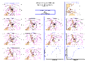
For The figure above shows verification of the MSLP fields valid 8 Nov 00 UTC. For high-resolution ps-file, click here. Already the HRES forecast from 10 days before had a cyclone in vicinity of the Philippines. In the forecast from the 3 and 4 November the cyclone starts to be more intense. However, the minimum pressure error is very large (60-70 hPa).
3.2 ENS
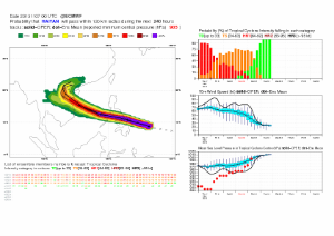
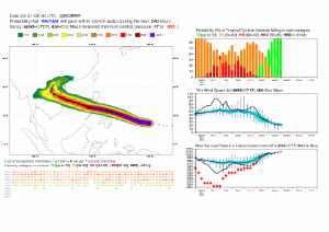
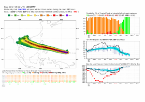
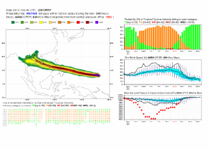
The figures above shows the strike probability product from 7, 6, 5 and 4 November 00 UTC. Here we see a very consistent ensemble regarding the track, but the ensemble has even higher minimum pressure than the HRES.
3.3 Monthly forecasts


Strike probability of a tropical storm for the period 4 to 10 November. forecasts from 4 Nov, 31 Oct, 28 Oct, 24 Oct and 21 October. As expected for above the forecast from 4 November had a high strike probability. For the earlier forecasts there is a risk for a cyclone (however we have to check how different the probabilities are from the climatology).
4. Experience from general performance/other cases
...
- Far to high minimum pressure
- Data assimilation makes the cyclone less intense.