Status: Finalised Material from: Linus, Laura et al.
1. Impact
The summer of 2018 was certainly one of the warmest and driest for northern Europe in recent history.
A hydrological summary can be found in the EFAS bulletin: https://www.efas.eu/download/efasBulletins/2018/bulletin_jun_jul_18.pdf
2. Description of the event
The plot below shows a map of the global temperature anomalies for JJA 2018, calculated from 00, 06, 12 and 18UTC ERA-Interim analyses.

The plot below shows a Howmoller plot of 850hPa temperature anomalies averaged between 50-55N, starting from 1 April on the bottom. The anomalous heat started already in April and May for central-northern Europe.

The plots below show time-series of 2-metre temperature at 12UTC (daily - thin, 7-day running mean - thick, mean climate - dashed) for Stockholm (left) and Madrid (right) from 1 April to 1 September. The period of Stockholm characterise by three warm periods and two breaks in between. For Madrid the summer temperature were close to average, but with a surge of heat in the beginning of August.


3. Predictability
3.1 Data assimilation
3.2 HRES
The plot below show time-series of 2-metre temperature between 16 and 22 July for Sodankyla (northern Finland) from HRES with hourly output (red) and synop observations (black). For these days the model under-predicted the daily cycle of temperature.

The plots below show bias in maximum (left) and minimum (right) 2-metre temperature for 1 June to 10 August 2018, indicating the that the diurnal cycle is underestimated.


3.3 ENS
As discussed in Section 2, the heatwave for Stockholm had a break in the end of June and the warmest temperatures occurred in the second half of July. The forecast evolution plots below focus on average temperature on 21-23 June (left) and 16-18 July (right). For the first (cold) case, the extended-range forecasts were warmer than normal, and the ensemble turned towards normal temperatures ~10 days before the event, and the ensemble median became colder than normal 3-4 days before the event. For the second event (warm), already the extended-range forecasts were warmer than normal and signal strengthened 10-15 days before the event.


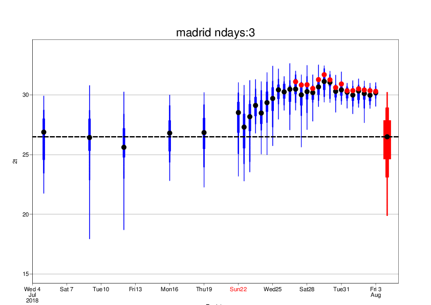
The ensemble ensemble evolution plot below shows the ENS (blue) and HRES (red dot) 3-day average temperature for the heat-surge in Madrid 3-5 August. The signal of the heat appeared in the ensemble 10-15 days before the event.
3.4 Monthly forecasts
The plots below show composites of weekly 2-metre temperature anomalies from monthly forecasts valid for 7 May to 12 August, based on ERA-Interim analysis (first plot), week 1 (second plot plot) to week 6 (last plot).


The plots below show weekly ensemble distribution of anomalies for 50N-60N, 10E-20E (blue) for week 2 (left) and week 3 (right), based on Monday forecasts. The panels also includes analysis (red) and reforecast distribution (grey).


3.5 Seasonal forecasts
The plots below show 2-metre temperature anomaly climagrams for northern Europe from seasonal forecast issue 1 April to 1 July.


The plots below show 2-metre anomalies for JJA from ECMWF (left), UKMO (middle) and MeteoFrance, all issued by C3S on 1 May.


The next plots show the same as above but for z500.


