Status: Finalised Material from: Fernando, Linus
Picture
1. Impact
A "destructive derecho" hit hard Iowa and Illinois states leaving 1.5 million people without power on 10 August. The social apps are saturated with videos and photos showing the damage left by this violent windstorm.
The derechos are not unusual phenomena in the United States. Based on the derecho climatology the Illinois states may experienced one event on average every year. The Storm prediction Centre did not have much time in advance to issue a severe warning for the region. According to The Washington Post "early Monday afternoon, the National Weather Service Storm Prediction Center issued a rare “particularly dangerous situation” severe thunderstorm watch". Many places in Illinois and neighbourhood states reported strong winds (>26 m/s) related to the derecho storm. The HRES forecasts on that day (10th Aug) indicate significant differences between the 00Z and 12Z forecast in handling of the windstorm as we can see by comparing the forecasts valid for the same time (12Z and 15Z). The location of the patterns of total precipitation rate associated to the derecho based on 10@00 forecast is distinct from the run initiated 12h later. As expected the wind gusts generated by the HRES are under-estimated (maxima under 18 m/s when reports systematically measured 26 m/s or above). The EFI of CAPE shows a broad area with large values (too large?) with the maximum displaced farther north from where the event occurred (seen by the cluster of wind reports in the map).
2. Description of the event
Climatology of derecho's storms (top-left), last minute SPC warning issued in the afternoon (UT, right)) and reports of strong winds (bottom left).

In the plot below we can see an animation of the evolution of the derecho storm generated by the Nasa Worldview service.

The plots below shows analyses of T850 and z500 from 8 August 00UTC to 12 August 00UTC, every 24 hours.


The plots below show analyses of MSLP and short forecasts of 6-hour precipitation from 10 August 00UTC, 10 August 12UTC and 11 August 00UTC.


3. Predictability
3.1 Data assimilation
3.2 HRES
HRES mslp & instantaneous total ppn rate forecasts initiated on 10@00 (top panels) and 10@12 (bottom panels) valid at 12Z and 15Z on 10 August.

HRES 10m maximum wind gust in the last 12 hours initiated on 10 Aug 12UTC valid on 11 August 03UTC.

The NexRad rainfall estimates highlight the issues the HRES had to handle the derecho windstorm. Overall the model tends to under-estimate the rainfall amounts associated with the phenomena. The HRES struggles to represent the convection at the initial stages, in particular across South dakota and Iowa.

HRES Simulated Satellite Image from 10 Aug 12UTC +06h (left) and 10 Aug 00UTC +18h (right) valid at 18Z of the same day


3.3 ENS
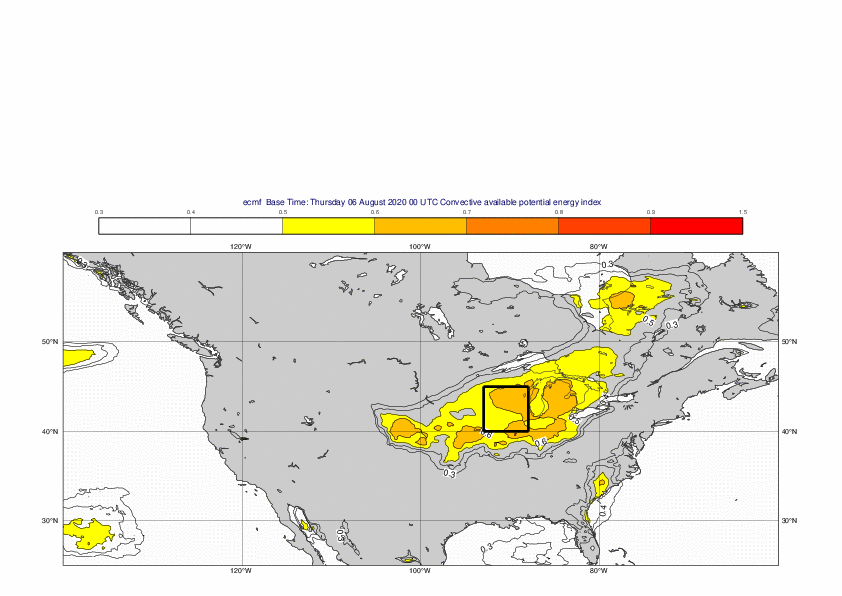
The plots below show the EFI for CAPE valid on 10 August from different lead times.


3.4 Monthly forecasts
3.5 Comparison with other centres
4. Experience from general performance/other cases
5. Good and bad aspects of the forecasts for the event
- Reasonable signal for the synoptic conditions (high EFI for CAPE)
- Also short-range forecasts missed the severe development
- Wind gusts clearly underestimated in cases of MSCs, as expected from earlier cases