-
Created by
 Linus Magnusson, last updated on Oct 17, 2024
7 minute read
Linus Magnusson, last updated on Oct 17, 2024
7 minute read
Status:Ongoing analysis Material from: Linus, Fernando
1. Impact
On 2 November huge impacts of storm Ciaran were seen across western Europe and (preliminary) killed 17 people. The South England and North of France, especially in Brittany, recorded the highest gusts with several places beating all time records. The most intense gusts were measured near coastlines but other places reported very strong gusts. Accordingly to the French media at least 1.2 million houses were left without power, and one person died. In the UK the disruption was significant as well; public transports halted and schools advised not to open this morning. The core pressure reached the one in 1987 (Great Storm) but the strongest winds were be seen on the south-southwest flank of Ciaran. The maxima winds occurred on the back-bent seclusion warm front encircle the centre of the storm. Brest (FR) was one of the places where the highest wind gusts (155 km/h) occurred beating the previous record. A radiosonde launched was launched near midnight few hours before the strongest gusts were reported, with winds up to 75 knots (38.6 m/s) at about 1 km height.
https://en.wikipedia.org/wiki/Storm_Ciarán
Link to post-event assessment of maximum wave height:
2. Description of the event
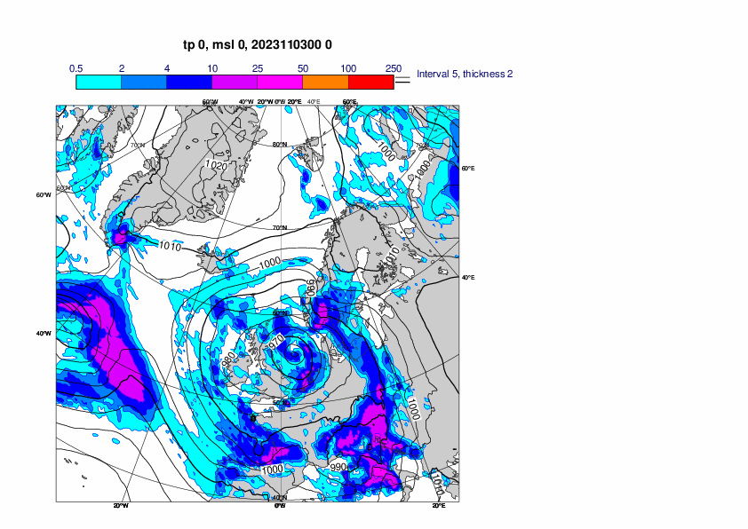
The plots below show analyses of MSLP and 6 hour rainfall from 31 October 00UTC to 3 November 00UTC, every 12th hour.


3. Predictability
3.1 Data assimilation
3.2 HRES
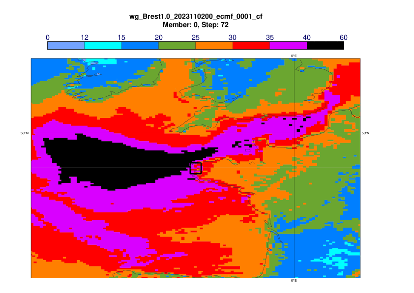
The plots below show 24-hour maximum wind gusts (2 November 00UTC - 3 November 00UTC) in observations (first plot) concatenated short forecasts (second plot) and ENS control forecasts with different lead times.


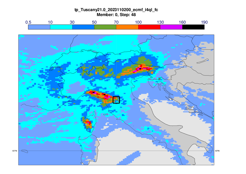
The plots below show 24-hour precipitation(2 November 00UTC - 3 November 00UTC) in observations (first plot) concatenated short forecasts (second plot) and ENS control forecasts with different lead times, focus on Tuscany, Italy. The observation plot will be updated once we have the HDOBS from Italy. While the orographic precipitation along the coast was captured to some degree, the forecasts missed the precipitation due to a convective system crossing the peninsula.


The plot below shows the same forecasts as above but for DestinE4.4km runs.


3.3 ENS
The plots below shows EFI for 1-day maximum wind gusts (2 November) from different initial dates.


The plots below show the cyclone feature maps valid 2 November 00UTC, with the dots coloured by the maximum wind speed at 1 km within 300 km radius. The isobars show the control forecast.


The plot below shows the forecast evolution plot for 24-hour maximum wind gust (2 November) inside a 0.5x0.5 box around Brest, Brittany. Observation - green hourglass, concatenated 6-hour forecasts - green dot, ENS control –red, ENS blue box-and-whisker, Model climate – cyan box-and-whisker. Ensemble mean as black diamonds. Triangle marks the maximum in the model climate based on 1600 forecasts.

The plots below shows EFI for 1-day precipitation (2 November) from different initial dates.


The plot below shows the forecast evolution plot for 24-hour precipitation (2 November) inside a 0.5x0.5 box centred on 43.9N, 11.1E in northern Tuscany, Italy. Observation - green hourglass, concatenated 6-hour forecasts - green dot, HRES–red, DEstniE4.4km - purple dot, ENS blue box-and-whisker, Model climate – cyan box-and-whisker. Ensemble mean as black diamonds. Triangle marks the maximum in the model climate based on 1600 forecasts.

The plot below shows the the forecast evolution plot for maximum significant wave height based on 00, 06, 12 and 18UTC on 2 November inside a 0.25x0.25 box around Les Pierres Noires off the coast of Brittany. Concatenated 6-hour forecasts - green dot, ENS control –red, ENS blue box-and-whisker, Model climate – cyan box-and-whisker. Ensemble mean as black diamonds. Triangle marks the maximum in the model climate based on 1600 forecasts. Below is also the map of the waves based on the analyses included, with the analysed box outliined.


3.4 Monthly forecasts
3.5 Comparison with other centres
4. Experience from general performance/other cases
5. Good and bad aspects of the forecasts for the event
- Good early predictions of the extreme winds over Brittany