Status:
...
Finalised Material from: Ivan
Discussed in the following Daily reports:
...
3.1 Data assimilation
3.2 HRES
HRES model forecast wet weather up to 5 days in advance with the very early forecasts jumping quite a lot. The HRES underestimated the heaviest precipitation in the E and especially in the SE of the country but in general produced more precipitation sense than observed in a broader area.
Gallery columns 6 includeLabel hresprecip sort comment
| columns | 6 |
|---|---|
| includeLabel | hresprecip |
| sort | comment |
HRES also gave a signal of some snow cover well in advance with more uncertainty (jumpy forecast) in the medium-range.
Gallery columns 7 includeLabel
...
hressnow sort comment
3.3 ENS
The EFI&SOT forecast for snowfall valid on for 25 October. Last two forecasts were very good at foreseeing the extreme snowfall. After that the signal is weakening very fast but it is still there up to 6 days in advance.
Gallery columns 5 includeLabel efisnow sort name
| columns | 5 |
|---|---|
| includeLabel | efisnow |
| sort | name |
The EFI&SOT for snowfall computed with an improved computational code and using a new climate that comprises 1980 values (11 members X 20 years X 5 weeks X 9runs (twice a week)).
Gallery columns 5 includeLabel efisnownew sort comment
The EFI&SOT forecast for total precipitation showed signal of wet conditions up to 5 days in advance in the most affected eastern parts of the country. Positive SOT indicates that some ensemble members forecast extreme precipitation (exceeding the 99th percentile of the model climate). Last few forecasts showed very high values of the EFI (>0.9) indicating a high risk of extreme precipitation.
Gallery columns 6 includeLabel efiprecip sort comment
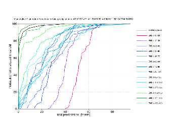
The CDFs of total precipitation for Burgas, the worst affected southern coast city, showing the evolution of the ENS.
3.4 Monthly forecasts
3.5 Comparison with other centres
...