Status:Finalised Material from: Ivan
Discussed in the following Daily reports:
Picture
1. Impact
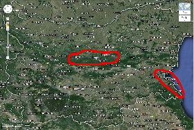
Heavy snowfall led to massive disruption in transport and power supply in parts of Bulgaria. Trees, still in leaf, collapsed and caused a widespread power outage. A state of emergency was declared in few municipalities in northern Bulgaria close to central part of the Balkan Mountain (Stara planina) where a snow cover of 40 to 50 cm formed just in 24 to 36 hours on Saturday 25th (see plots of snow cover below). The photos below were taken from one of the most affected regions. Torrential rain hit southern Black Sea coast and caused flooding in Burgas district.


Snow Gabrovo
Snow Tryavna
Snow Tryavna
Snow Troyan
|
|
|
|
|
|
Snow Gabrovo
|
Snow Tryavna
|
Snow Tryavna
|
Snow Troyan
|
The most affected regions are marked in red on the map below.
2. Description of the event
Heavy precipitation fell in the northern slopes and the adjacent areas of Stara planina. Orographic enhancement of precipitation may play role in this case.


Deep snow cover formed in the areas close to central Stara planina mainly throughout Saturday 25th October.


ECMWF snow analysis (27 Oct 00UTC) and observed snow depth (27 Oct 06UTC). There is a good agreement between analysis and observations.

A rapid cyclogenesis occurred over the Ionian Sea and moved eastwards towards the Aegean Sea where the cyclone started filling. The cyclone formed over an active cold front following the dissipation of the ex-hurricane Gonzalo that hit Western Europe earlier that week. The combination of that Mediterranean cyclone and an anticyclone to the north-northeast brought very cold air for the season.
Mean Sea Level Pressure and 10-metre wind ECMWF analyses


3. Predictability
3.1 Data assimilation
3.2 HRES
HRES model forecast wet weather up to 5 days in advance with the very early forecasts jumping quite a lot. The HRES underestimated the heaviest precipitation in the E and especially in the SE of the country but in general produced more precipitation sense than observed in a broader area.


01. 25 Oct 00UTC
02. 24 Oct 12UTC
03. 24 Oct 00UTC
04. 23 Oct 12UTC
05. 23 Oct 00UTC
06. 22 Oct 12UTC


07. 22 Oct 00UTC
08. 21 Oct 12UTC
09. 21 Oct 00UTC
10. 20 Oct 12UTC
11. 20 Oct 00 UTC
|
|
|
|
|
|
|
|
01. 25 Oct 00UTC
|
02. 24 Oct 12UTC
|
03. 24 Oct 00UTC
|
04. 23 Oct 12UTC
|
05. 23 Oct 00UTC
|
06. 22 Oct 12UTC
|
|
|
|
|
|
|
|
|
07. 22 Oct 00UTC
|
08. 21 Oct 12UTC
|
09. 21 Oct 00UTC
|
10. 20 Oct 12UTC
|
11. 20 Oct 00 UTC
|
HRES also gave a signal of some snow cover well in advance with more uncertainty (jumpy forecast) in the medium-range.


3.3 ENS
The EFI&SOT forecast for snowfall valid for 25 October. Last two forecasts were very good at foreseeing the extreme snowfall. After that the signal is weakening very fast but it is still there up to 6 days in advance.


01. 25 Oct 00UTC
02. 24 Oct 12UTC
03. 24 Oct 00UTC
04. 23 Oct 12UTC
05. 23 Oct 00UTC


06. 22 Oct 12UTC
07. 22 Oct 00UTC
08. 21 Oct 12 UTC
09. 21 Oct 00 UTC
10. 20 Oct 12 UTC
|
|
|
|
|
|
|
01. 25 Oct 00UTC
|
02. 24 Oct 12UTC
|
03. 24 Oct 00UTC
|
04. 23 Oct 12UTC
|
05. 23 Oct 00UTC
|
|
|
|
|
|
|
|
06. 22 Oct 12UTC
|
07. 22 Oct 00UTC
|
08. 21 Oct 12 UTC
|
09. 21 Oct 00 UTC
|
10. 20 Oct 12 UTC
|
The EFI&SOT for snowfall computed with an improved computational code and using a new climate that comprises 1980 values (11 members X 20 years X 5 weeks X 9runs (twice a week)).


The EFI&SOT forecast for total precipitation showed signal of wet conditions up to 5 days in advance in the most affected eastern parts of the country. Positive SOT indicates that some ensemble members forecast extreme precipitation (exceeding the 99th percentile of the model climate). Last few forecasts showed very high values of the EFI (>0.9) indicating a high risk of extreme precipitation.


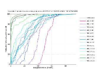
The CDFs of total precipitation for Burgas, the worst affected southern coast city, showing the evolution of the ENS.
3.4 Monthly forecasts
3.5 Comparison with other centres
4. Experience from general performance/other cases